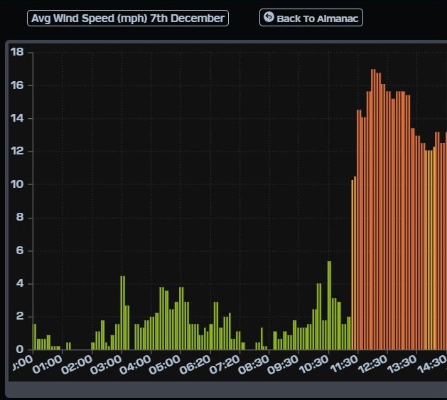
¡Buenos dias! The thickening high clouds that crept up from the south yesterday put a lid on our developing thermal, and while the wind gauge at the campground showed sustained winds peaked at 15-17 mph, it only lasted for about 1.5 hours (see nerd note below). Infrared satellite loops early this morning showed persistent thick, mid-level clouds over our area, but all of the latest model forecasts show these should begin to move off to the east around noon today and give us a window this afternoon for our local thermal to al least partially kick in. An Oceansat satellite pass last evening measured 10 knot NNW background flow over the southern Sea of Cortez but model forecasts show the background flow will weaken a bit this afternoon and approach the lower threshold for activating our local wind machine. Bottom line is it’ll be really close today. The latest model forecasts for Monday show sufficient north background flow and with mostly sunny skies expected, we should see a rideable afternoon. The norte is still on track to hit Tuesday, with typical first day norte gusty conditions expected. Low-end norte conditions should last though Wednesday, with better quality winds expected. The latest model forecasts for Thursday through Saturday are a hot mess, with models showing significant differences in the overall surface pressure pattern over our region. At this point it looks like we may see rideable wind each day, but confidence is very low.
- Today…Cloudy this morning, then becoming mostly sunny this afternoon. North wind 14-16 mph.
- Monday…Mostly sunny. North wind 16-18 mph.
- Tuesday…Partly sunny. North wind 22-26 mph and gusty.
- Wednesday…Sunny. North wind 20-24 mph.
- Thursday…Sunny. North wind 16-18 mph.
- Friday…Sunny. North wind 16-18 mph.
- Saturday…Mostly sunny. North wind 18-22 mph.
Nerd Note: Yesterday was a great example of how sensitive our local wind machine is to cloud cover. The wind gauge at the campground measured winds at 15-17 mph from just before noon to a little after 1 pm (see graph). Satellite images from just before noon showed a narrow clear slot in the high cloud shield right over us. That’s about the time that the winds peaked, but by around 1 pm the clouds had quickly moved back in and our winds dropped rapidly.

