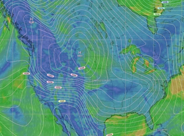
¡Buenos dias! Multiple polar-orbiting satellite passes last evening measured 15 knot winds over the Sea of Cortez east of Cerralvo, but all of the most recent model forecasts show the background flow weakening this morning to below the threshold to activate our wind machine. Our down time will be short, as strong surface high pressure will build into the 4-corners area of the U.S. on Tuesday, with norte conditions developing here. The norte will likely last through Wednesday, as a reinforcing area of high pressure moves from the Pacific Northwest of the U.S. into Idaho and keeps a very tight surface pressure gradient in place over BCS. Although there will likely be times of thin, high clouds both Tuesday and Wednesday, the primary driver of our winds will be the norte so a slightly dampened thermal shouldn’t make any difference. Sunny skies are forecast to return on Thursday, and although the norte should ease, we will likely see another windy afternoon. The surface high centered far to our north will weaken on Friday, but ample north background flow will continue and team up with full sunshine to give us another good day. All of the long-range models are in good agreement that surface low pressure will rapidly form over the southwestern U.S. on Saturday, with our background flow becoming light. The low will likely linger to our north through Sunday, with another down day likely. Looking farther into the following week, both the European and American long-range models show north flow returning on Monday the 27th, with another long stretch of windy days looking likely.
- Today…Some morning high clouds, then becoming sunny. Northeast wind 10-12 mph.
- Tuesday…Mostly sunny. North wind 22-26 mph and gusty.
- Wednesday…Mostly sunny. North wind 22-26 mph.
- Thursday…Sunny. North wind 20-24 mph.
- Friday…Sunny. North wind 16-20 mph.
- Saturday…Sunny. East wind 8-10 mph.
- Sunday…Sunny. East wind 8-10 mph.
Nerd Note: A massive arctic airmass stretching from the east coast of the U.S. into British Columbia this morning will produce a variety of hazardous weather over much of the U.S. over the next few days. Extreme cold warnings stretched from the upper Midwest into southwestern Texas, with cold weather advisories covering much of the remainder of the country from the Rockies eastward to the Atlantic coast. The very strong pressure gradient over southern California will lead to extreme fire weather conditions over parts of southern California today and Tuesday, where Santa Ana winds will gust to 60-80 mph. Farther east, an extremely rare snowstorm is forecast the I-10 corridor stretching from Houston to New Orleans where 4-6 inches of snow looks likely on Tuesday.
