¡Buenos dias! An ASCAT pass late last evening showed the leading edge of the norte had reached as far south as Loreto, with 25 knot winds measured over the Sea of Cortez from there northward. Some of the wind gauges here were already measuring wind gusts in the mid 20s early this morning, and all of the most recent model forecasts show norte conditions developing here today. As is typical for the first day of a norte, we will likely see some west component to the wind, with variable, gusty conditions near shore with the strongest winds staying a distance offshore. Infrared satellite loops early this morning showed patches of high clouds (see nerd note below) moving in from the southwest, but the thickest cloud cover should remain to our north. Models continue to show a reinforcing surface high will build into the interior west from British Columbia on Wednesday and keep a tight surface pressure gradient over BCS. Strong north background flow will likely continue through Thursday, then east a bit on Friday as the surface high centered far to our north weakens. Model forecasts are in excellent agreement that as an elongated surface low forms over the southwestern U.S. on Saturday, our background flow will become very light. The low to our north will likely linger through Sunday, then long-range model forecasts show surface high pressure again building into BCS…possibly as early as Monday.
- Today…Mostly sunny. North/northwest wind 20-24 mph (variable and very gusty near shore).
- Wednesday…Mostly sunny. North wind 22-26 mph and gusty.
- Thursday…Sunny. North wind 20-24 mph.
- Friday…Sunny. North wind 18-22 mph.
- Saturday…Sunny. East wind 8-10 mph.
- Sunday…Mostly sunny. East wind 8-10 mph.
- Monday…Mostly sunny. North wind 16-18 mph.
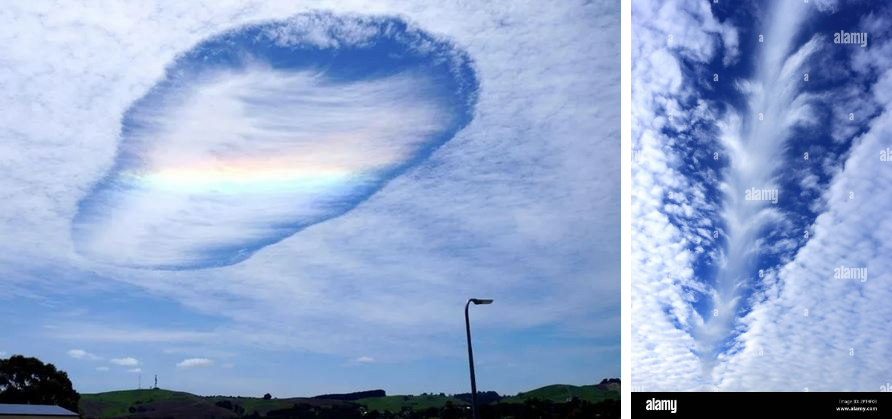
Nerd Note: Many of you posted pictures of some very strange cloud formations yesterday (see below). These are known as cavum, or hole punch clouds. They are formed as super-cooled water droplets in high-level clouds freeze.
Pure liquid water freezes at a temperature well below 0 degrees Celsius (32 Fahrenheit), and this commonly leads to super-cooled liquid clouds. Here is a great explanation from the BBC https://www.youtube.com/watch?v=tRGYhkr-5sw
What we witnessed yesterday was likely caused as a jet flew through supercooled liquid clouds. Impurities in the jet exhaust acted as freezing nuclei and ice crystals rapidly formed, thereby changing the appearance of the cloud field. You can see both a jet track and a ‘punch hole’ formed as ice crystals scavenged up surrounding supercooled liquid droplets in the stock pictures below.
