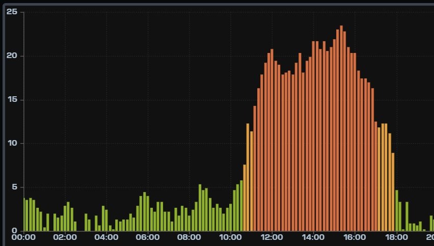
¡Buenos dias! An Oceansat pass last evening measured 15-20 knot NW winds over the Sea of Cortez just east of Cerralvo. Surface high pressure centered near Salt Lake City this morning will hold tight today, with solid north background flow continuing over BCS. We lucked out yesterday with the cloud cover, as significant breaks allowed for a strong thermal. The wind gauge at the campground (see graph below) recorded 10 minute average sustained winds of 18-20 mph from around 11:30 am until 2 pm, then a peak of 21-23 mph between 2 and 3:40 pm, with kiteable winds lasting until 5 pm. We may not be so fortunate today, as infrared satellite loops show thick, high cloud cover streaming in from the southwest. There is a glimmer of hope that we will see some partial late-morning clearing which should allow for at least a partial thermal boost, so I’ll be optimistic that we’ll sneak in another windy afternoon. The surface high centered far to our north is forecast to weaken on Tuesday, with background flow over BCS becoming light. Similar light flow is expected on Wednesday, then a relatively weak pulse of north wind, combined with full sunshine on Thursday, may bring us a windy afternoon. Light flow is forecast to return on Friday and last through Saturday.
- Today…Mostly cloudy. North wind 18-22 mph.
- Monday…Mostly sunny. North wind 16-20 mph.
- Tuesday…Sunny. North wind 12-14 mph.
- Wednesday…Mostly sunny. East wind 8-10 mph.
- Thursday…Sunny. North wind 16-18 mph.
- Friday…Mostly sunny. Northeast wind 10-12 mph.
- Saturday…Sunny. East wind 8-10 mph.