Wind – February 24, 2025

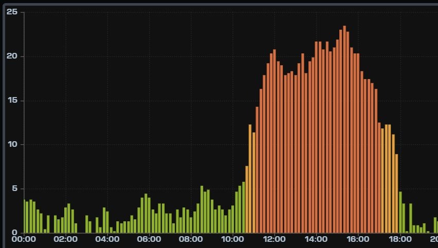
¡Buenos dias! An Oceansat satellite pass around midnight measured solid 15 knot NW winds just east of Cerralvo. Model forecasts are in good agreement that the surface pressure gradient will tighten over our region today, with background NW flow increasing. The bad news it that all of the latest model runs show a large west component to the flow, so expect wind-shadowed and gusty conditions, especially on the northern beaches. Sufficient background flow should last into Tuesday, and we should see the background flow veering to a more north direction, with better quality winds. Wednesday still looks like a down day as the background flow becomes very light. Models are starting to be in better agreement that a pulse of north flow will return on Thursday, and may last into Friday. Long-range forecasts are a bit muddy, but if an E-W oriented ridge of high pressure sets up just to our north as some suggest it will, we should see enough north flow combined with sunny skies to trigger our local wind machine through the weekend.
Today…Mostly sunny. North…northwest wind 18-22 mph and gusty, especially along northern beaches.

  • Tuesday…Sunny. North wind 16-18 mph.
  • Wednesday…Sunny. East wind 8-10 mph.
  • Thursday…Sunny. North wind 16-18 mph.
  • Friday…Sunny. Northeast wind 16-18 mph.
  • Saturday…Sunny. North wind 16-18 mph.
  • Sunday…Sunny. North wind 16-18 mph.

Wind – February 23, 2025

¡Buenos dias! An Oceansat pass last evening measured 15-20 knot NW winds over the Sea of Cortez just east of Cerralvo. Surface high pressure centered near Salt Lake City this morning will hold tight today, with solid north background flow continuing over BCS. We lucked out yesterday with the cloud cover, as significant breaks allowed for a strong thermal. The wind gauge at the campground (see graph below) recorded 10 minute average sustained winds of 18-20 mph from around 11:30 am until 2 pm, then a peak of 21-23 mph between 2 and 3:40 pm, with kiteable winds lasting until 5 pm. We may not be so fortunate today, as infrared satellite loops show thick, high cloud cover streaming in from the southwest. There is a glimmer of hope that we will see some partial late-morning clearing which should allow for at least a partial thermal boost, so I’ll be optimistic that we’ll sneak in another windy afternoon. The surface high centered far to our north is forecast to weaken on Tuesday, with background flow over BCS becoming light. Similar light flow is expected on Wednesday, then a relatively weak pulse of north wind, combined with full sunshine on Thursday, may bring us a windy afternoon. Light flow is forecast to return on Friday and last through Saturday.

  • Today…Mostly cloudy. North wind 18-22 mph.
  • Monday…Mostly sunny. North wind 16-20 mph.
  • Tuesday…Sunny. North wind 12-14 mph.
  • Wednesday…Mostly sunny. East wind 8-10 mph.
  • Thursday…Sunny. North wind 16-18 mph.
  • Friday…Mostly sunny. Northeast wind 10-12 mph.
  • Saturday…Sunny. East wind 8-10 mph.

Wind – February 22, 2025

¡Buenos dias! Satellilte-derived NW winds of 5-10 knots were common over the southern Sea of Cortez last evening. All of the latest numerical model runs show surface high pressure centered just north of Salt Lake City this morning will send a new surge of north flow into BCS today, but the big wild-card for the next few days will be the thickness of high cloud cover and how much it will dampen our local thermal. Infrared satellite loops early this morning showed substantial high clouds moving in from the southwest, but many of the model forecasts show some breaks in the cloud cover as well, so we may see at least a partial thermal boost. Similar conditions are expected on Sunday, and Monday, with the surface high to our north gradually weakening on Monday. Tuesday will be a transition day, but at this point it looks like just enough north flow will remain to combine with full sunshine and give us another windy afternoon. A light wind regime is then forecast to set up over BCS on Wednesday as the surface pressure gradient becomes very weak. We may see a slight bump in the north flow next Thursday but long-range model forecasts show light winds will likely return again on Friday.

  • Today…Mostly sunny. North wind 18-22 mph.
  • Sunday…Mostly sunny. North wind 18-22 mph.
  • Monday…Mostly sunny. North wind 16-20 mph.
  • Tuesday…Sunny. North wind 16-18 mph.
  • Wednesday…Sunny. East wind 8-10 mph.
  • Thursday…Sunny. North wind 14-16 mph.
  • Friday…Mostly sunny. East wind 8-10 mph.

Wind – February 21, 2025

¡Buenos dias! A couple of satellite passes late last evening measured light and variable winds over the Sea of Cortez just east of Cerralvo. Today’s forecast is a low-confidence one, as the latest model forecasts show the background flow will be near or just below the lower threshold for fully activating our wind machine. Several of the more reliable models do show just enough north flow this afternoon, and with full sunshine returning, there is some room to be optimistic for marginally kiteable wind this afternoon, particularly on the northern beaches. The remainder of the forecast looks on track, with solid north flow returning on Saturday and lasting at least through Monday. Tuesday will see weaker north flow, but we may get one more windy day before we enter into a weak wind regime on Wednesday.

  • Today…Sunny. North wind 16-18 mph.
  • Saturday…Mostly sunny. North wind 18-22 mph.
  • Sunday…Mostly sunny. North wind 16-20 mph.
  • Monday…Mostly sunny. North wind 16-20 mph.
  • Tuesday…Sunny. North wind 16-18 mph.
  • Wednesday…Sunny. East wind 8-10 mph.
  • Thursday…Sunny. East wind 8-10 mph.

Wind – February 20, 2025

¡Buenos dias! A Haiyang satellite pass around midnight measured NW winds around 10 knots over the Sea of Cortez just east of Cerralvo, and all of the most recent numerical model forecasts show similar north background flow will continue today. While it now appears that the background flow will be sufficient to trigger our wind machine today, the big wild card will be the thickness of high cloud cover. Infrared satellite loops early this morning showed an area of clearing over our area, but another patch of thick high clouds was lurking to the southwest and most model forecasts bring it close to or over us this afternoon. That said, there are some indications that some of the models are over-forecasting the extent of the high clouds, so I’ll be optimistic and forecast just enough sun to bring us at least a partial thermal boost this afternoon. Friday will be a close call as well, as several of the latest models now show the background north flow increasing a bit during the afternoon and full sunshine returning, so I’ll keep the positive vibes going and call for another kiteable day. The remainder of the forecast looks on track, as surface high pressure centered over northern Utah will remain locked in place from Saturday through Monday and bring ample north background flow to our region. While we will see periods of high clouds, there should be enough breaks in the cloud cover to allow for at least partial thermal boosts each day. The surface high is forecast to weaken on Tuesday, but just enough north flow should remain to couple with full sunshine and give us another windy afternoon. Long-range models forecasts are in good agreement that the surface pressure gradient will become very weak by next Wednesday, with only light onshore breezes expected.

  • Today…Mostly sunny. North wind 16-18 mph.
  • Friday…Sunny. North wind 16-18 mph.
  • Saturday…Mostly sunny. North wind 18-22 mph.
  • Sunday…Mostly sunny. North wind 16-20 mph.
  • Monday…Mostly sunny. North wind 16-20 mph.
  • Tuesday…Sunny. North wind 16-18 mph.
  • Wednesday…Sunny. East wind 8-10 mph.

Wind – February 19, 2025

¡Buenos dias! An ASCAT satellite pass late last evening measured light and variable winds over the southern Sea of Cortez, but the latest model forecasts all show solid north background flow returning to our area this afternoon. Infrared satellite loops indicated clear skies over BCS, and with a sunny day ahead we will see our local thermal in fine form. The ridge of high pressure over the southwestern U.S. is forecast to weaken on Thursday, and with some high clouds moving in, we may see marginal winds at best. Surface high pressure will build into the western U.S. on Friday, but the models have again flipped, and now delay the onset of substantial north flow until Saturday. High pressure will remain locked in place over northern Utah through the upcoming weekend and into Monday, with ample north background flow expected. While there will likely be periods of high clouds Saturday through Monday, we should see enough filtered sunshine each day to give us at least a partial thermal boost. The surface high far to our north is then forecast to weaken on Tuesday, with north flow over BCS decreasing.

  • Today…Sunny. North wind 18-22 mph.
  • Thursday…Mostly sunny. North wind 14-16 mph.
  • Friday…Sunny. Northeast wind 12-14 mph.
  • Saturday…Mostly sunny. North wind 18-22 mph.
  • Sunday…Mostly sunny. North wind 18-22 mph.
  • Monday…Sunny. North wind 16-20 mph.
  • Tuesday…Sunny. North wind 14-16 mph.

Wind – February 18, 2025

¡Buenos dias! A Haiyang satellite pass early this morning measured SW winds of around 5 knots over the Sea of Cortez just east of Cerralvo, and model forecasts all show light background flow will continue today. Infrared satellite loops early this morning showed some relatively thin, high clouds streaming in from the southwest, but we should see plenty of sunshine as well this afternoon, with a light onshore breeze developing. A narrow ridge of high pressure will move into the southwestern U.S. on Wednesday and send a fresh pulse of north flow down the Sea of Cortez, and with full sunshine forecast to return, we will likely see a windy afternoon. The surface pressure gradient is forecast to weaken on Thursday, and depending on the thickness of high cloud cover, it looks like we could see a marginal day. Models are flip-flopping on the forecast for Friday, with the majority of the latest runs now showing surface high pressure building into the interior west of the U.S. and north background flow increasing over our area. Models are also showing a return of full sunshine on Friday, so at this point it looks like we should see a kiteable day. Long-range models are in good agreement that surface high pressure will remain anchored far to our north from Saturday through Monday, with ample north flow over BCS. The big wild card for Saturday through Monday will be the thickness of high cloud cover, but for now it looks like we will see enough filtered sunshine each day to trigger our local thermal.

  • Today…Mostly sunny. East wind 8-10 mph.
  • Wednesday…Sunny. North wind 18-22 mph.
  • Thursday…Mostly sunny. North wind 14-16 mph.
  • Friday…Sunny. North wind 16-18 mph.
  • Saturday…Mostly sunny. North wind 18-22 mph.
  • Sunday…Mostly sunny. North wind 16-20 mph.
  • Monday…Mostly sunny. North wind 16-18 mph.

Wind – February 17, 2025

¡Buenos dias! An Oceansat satellite pass around midnight measured 15 knot winds just east of Cerralvo, but all of the latest numerical model runs continue to insist that the ample north background flow we’ve enjoyed lately will rapidly weaken this morning and fall to levels just below what would normally trigger our local wind machine (see nerd note below). Another potential negative for today will be patches of high clouds which may at times partially dampen our local thermal. That said, it’ll be close…and I wouldn’t be surprised to see a couple hours of kiteable wind this afternoon especially on the northern beaches. Models are in excellent agreement that an E-W oriented trough of low pressure will linger over the southwestern U.S. on Tuesday, with very light background flow over BCS. Surface high pressure will build back into the interior west of the U.S. on Wednesday and send a fresh pulse of north flow into the southern Sea of Cortez, and with full sunshine returning, we should see a good thermal boost as well. Thursday will be another nail-biter, as model forecasts show the background flow weakening and patchy high clouds moving in. Surface high pressure will begin building into the western U.S. on Friday, but it now appears that we’ll have to wait one more day for the next surge of north flow. The upcoming weekend looks good at this point, with ample north flow and only some thin patches of high clouds at times.

  • Today…Mostly sunny. Northeast wind 10-12 mph.
  • Tuesday…Sunny. East wind 8-10 mph.
  • Wednesday…Sunny. North wind 18-22 mph.
  • Thursday…Mostly sunny. North wind 14-16 mph.
  • Friday…Sunny. East wind 8-10 mph.
  • Saturday…Mostly sunny. North wind 18-22 mph.
  • Sunday…Mostly sunny. North wind 16-20 mph.

Nerd note: Several of you have asked about the minimum threshold of north background flow I use as part of the forecast process. I typically look at a point about halfway between the northern tip of Cerralvo and the Cacachilas Mountains (see graphic). If the model forecast background flow is at least 7 mph, AND we are expecting sunny skies, then it will likely be a go day. That said, there are at least 6 numerical models I look at, and they can vary substantially in their forecasts. If there is a general consensus, then it lends more confidence to the forecast. For example in the graphic below, today’s model forecasts all show the background flow below 7 mph, so it’s more likely that it’ll be a down day. In addition, infrared satellite loops and model forecasts show some patches of relatively thin, high cloud that could partially dampen our local thermal. Place your bets…

Wind – February 16, 2025

¡Buenos dias! Multiple satellite passes missed the southern Sea of Cortez last evening, but all of the most recent numerical model forecasts show moderate to strong north background flow will continue today. Surface high pressure centered just north of the 4-corners area of the U.S. this morning will begin to rapidly weaken this evening and by Monday all of the latest model runs show the background north flow falling below the minimum threshold to trigger our wind machine. The models are in good agreement that an area of low pressure will form over the southwestern U.S. on Tuesday, with winds over BCS remaining light. A ridge of high pressure is then forecast to build into the southwestern U.S. on Wednesday, with solid north flow returning to our region. The pulse of north flow will be short-lived however, as Thursday will likely be a marginal day with the background north flow forecast to weaken and hover right around the go/no go speed. Long-range model forecasts are in good agreement that surface high pressure will build into the western U.S. on Friday, with moderate north flow returning to BCS. The high will likely remain nearly stationary through the following weekend, and with sunny skies expected, we should see a great stretch of windy days.

  • Today…Sunny. North wind 20-24 mph.
  • Monday…Mostly sunny. Northeast wind 10-12 mph.
  • Tuesday…Sunny. East wind 8-10 mph.
  • Wednesday…Sunny. North wind 18-22 mph.
  • Thursday…Mostly sunny. North wind 14-16 mph.
  • Friday…Sunny. North wind 16-20 mph.
  • Saturday…Sunny. North wind 18-22 mph.

Wind – February 15, 2025

¡Buenos dias! An Oceansat satellite pass around midnight measured 10 knot WNW winds over the Sea of Cortez just east of Cerralvo, but all of the latest numerical model runs show surface high pressure will build into the interior west of the U.S. today, with the background flow over BCS becoming more northerly and increasing substantially this afternoon. Moderate to strong north flow is forecast to continue over our region on Sunday, and with sunny skies expected, we should see an added thermal boost as well. Models are in good agreement that the surface high far to our north will rapidly weaken on Monday, with north flow decreasing to near or below the lower threshold to trigger our local wind machine. At this point I’ll be optimistic and say we will have just enough remaining north background flow to combine with a mostly sunny afternoon and give us rideable conditions. A trough of low pressure is forecast to spread across the southwestern U.S. on Tuesday, and this will create very light background flow over BCS, with only light onshore flow expected here. Surface high pressure is forecast to build back into the interior west of the U.S. on Wednesday, with increasing north flow over our area. Long-range model forecasts differ substantially, but some show just enough north background flow remaining to help trigger our wind machine into next Friday…stay tuned.

  • Today…Mostly sunny. North wind 20-24 mph and gusty.
  • Sunday…Sunny. North wind 20-24 mph.
  • Monday…Mostly sunny. North wind 14-16 mph.
  • Tuesday…Sunny. East wind 8-10 mph.
  • Wednesday…Sunny. North wind 18-22 mph.
  • Thursday…Mostly sunny. North wind 16-18 mph.
  • Friday…Sunny. North wind 16-18 mph.