The Cabalerra de Cerralvo (Part 2)

Part 1 ended with Daphne’s recollection of the aftermath of the earthquake… “The next morning, we launched on a tide flowing out of the Gulf toward the Cape. As it carried us back to Delicias, we drifted farther away from land. I screamed at Dana to pull harder, but the current’s grip on us overcame our efforts to paddle to shore, and it began to take us into the dreaded Cerralvo Channel and out to sea.”

Part 2

“I was ready to abandon our life-saving water cargo and swim for the beach, but after praying for help, another current pulled us back, and we beached the boat. Once we arrived, only force-feeding our prostrate burros and horses with a mixture of water, cornmeal, and panocha, a coarse-grain sugar, revived them.” 

Continue reading “The Cabalerra de Cerralvo (Part 2)”

La Ventana Bay Beach-Sand Dynamics

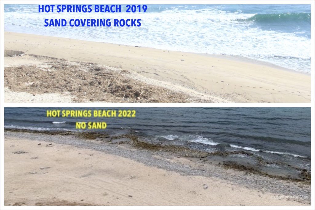
Ocean beaches the world over change with the seasons and long-term weather events. La Ventana Bay beaches have these same dynamics but with less wave action. Beach sand comes and goes and is related to weather events and currents. Around La Ventana Bay, there will be years of no sand, and in other years there will be a significant amount of sand on the beaches. People who have spent their lives in La Ventana can testify to these decade-long changes. They might recall that 20 years ago, a beach had mostly rock boulders and just a small amount of sand near the bluff base. But they also remember when they first came here around 1987, the same beach was twice as wide as it is now. But no data was written down by anyone involving dates, amounts, etc.  

Continue reading “La Ventana Bay Beach-Sand Dynamics”

History of La Ventana

Part 2 — The First Settlers

Salomé’s caravan made its way over the dusty trail from La Paz to the palm grove on the Bahia de La Ventana, stopping to camp one night in the mountains. Salomé later commented that he was so weary by the journey’s end that even the hat on his head was too much weight to bear.

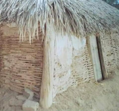
Salomé and his sons scoured the surrounding desert for palo de arco and downed cardón trunks to build a shelter. They chose a construction site under a stand of palm trees on the north side of the palmar overlooking the bay and Isla Cerralvo. They used the cardón for the corner posts and roof beams, wove the palo-de-arco walls and plastered them with mud. Then they attached layers of palm fronds to the roof and left the dirt floor bare. This type of shelter, called a  jacal, was standard in many rural communities of Mexico in those times.

A rural Mexican shelter called a jacal.

The home was illuminated with oil lamps and candles, and Salome furnished it with a table, chairs, and beds of cardón cactus tied together with palm rope. A blanket separated the interior into two rooms. Salome’s second wife, Petra, cooked on a metal grate over a wood fire. A typical meal consisted of beans, rice, corn tortillas, and fish. After the men brought goats back from the Island, meals included cheese and meat. The children collected wild fruit and herbs from the desert.

Rosendo Amador, who had herded cattle at Punta Perico with his son Jesus, had already brought his family to the palmar and built their jacal at the south end, where he also dug a well. The two pioneer families relied on each other for survival. The marriage between Jesus Amador Hiraldo and María Teresa León Zazueta, the children of Rosendo and Salomé, would seal the close bond between the two families.

Continue reading “History of La Ventana”

Salomé León and the Founding of La Ventana

For a century and a half, pearl divers repeatedly overfished and abandoned the pearl grounds along the east coast of Baja California. The pearl beds replenished themselves in a few decades before being overfished again. In 1697, when Charles the II learned that license holders spent more time gathering pearls than mapping and searching for settlement sites as the permit required, he rescinded those licenses. When the Jesuits took over administering economic activity on the peninsula, they prohibited pearl collecting for mission workers; others could get permission as long as they paid the Spanish Crown his quinto de perlas, one-fifth of the pearls they found. The Jesuits also suggested payment for themselves of one-tenth.

A century after Spain expelled the Jesuits from Baja, the pearling industry in La Paz took off. Armadores (fishing fleet owners) hired mostly Yaqui Indians from Sonora to dive for pearls. Some Yaqui Indians could dive to 20 fathoms, 120 feet, equipped only with a loincloth, knife, and catch-bag. But deaths from a variety of hazards were high.

Divers in canoes fanned out from the mother ships to dive for the madreperlas (pearl oysters). Many Yaqui divers and their families migrated to La Paz when the Territorial Deputies imposed higher duties on the armadores who hired non-residents divers. That may have included an ancestor of the future co-founder of La Ventana.

Onshore, workers opened the mollusks to look for pearls. Then they cleaned the mother-of-pearl shells and sorted them for export to Europe, where artisans used them to make buttons, inlaid tabletops, and other items. Mother-of-pearl soon brought in more money than the pearls themselves.

In 1874, an Italian and an American arrived in La Paz with diving suits and air pumps that they had used for pearl fishing in the Gulf of Panama. Divers outfitted with this equipment could harvest oyster beds deeper than 80 feet, an extreme limit for most freedivers. They sold pearls for as much as 60 times the cost of collecting them and retired after only six months of work.

As other outfitters began importing similar equipment, La Paz became the pearling capital of the world. Pearl fishing companies usually equipped small fishing boats with an air pump, a buzo (diver), two pump operators, and two rowers. A life-line man helped divers into their heavy diving suits, kept the air hoses untangled, and helped raise the buzo to the surface after a time that depended on the depth reached. It could be an hour or more in shallow waters, but only a short time from sea floors too deep for free diving.

By the early 1900s, business was booming in La Paz, a growing town of some 10,000 people.

Continue reading “Salomé León and the Founding of La Ventana”

Early Explorers of La Ventana Bay

Pericu Indians

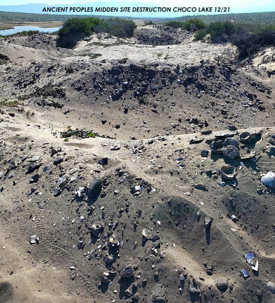
Time: 5,000 years ago. Location: Bufadora and Choco Lake area of present-day Bay of La Ventana. At dawn’s first light, the men started searching for shellfish in the shallows along the shore in front of the shell-midden dunes left by their ancestors. The women finished gathering acorns from the woodland where they had camped for the past moon.  While they prepared the oak seeds for soaking to remove their bitter taste, they discussed moving camp to the base of the mountains where pitaya was ready to harvest.

Illegal destruction of the archaeological site on Lake Choco

A young girl approached the leader and asked her, “Where did our people come from?”  

The old woman repeated the story she had learned from her mother: “Many winters ago, just before dawn on the shortest day of the season, Niparaya descended from the minyikári (sky) on the three stars that form the great hunter’s waist.  He stood on Cerro Del Puerto, the sacred mountain to the west, and created all we need to survive. Pericú is the name he gave us. It means “The People.”

Continue reading “Early Explorers of La Ventana Bay”

Baja Hurricanes

La Paz

The Baja Peninsula is the third-longest globally, stretching 747 miles from the border at Tijuana to Land’s End at Cabo San Lucas. Drive the Transpeninsular Highway though and you will log closer to 1061 miles.[1] The new road, completed in 1973, created a demand for cheap labor in tourism and agriculture. People from the mainland came to La Paz seeking better-paying jobs and a safe place to live. But many could only afford to put up tar paper shacks on the banks and dry streambeds of arroyos on the southwest edge of town.

Earlier settlers had built homes on a web of north-south running arroyos in La Paz that were sometimes dry for several years at a time. These arroyos secos were eventually filled in, paved over, and served as the main streets of the central downtown area. During a downpour, they often flood.

In 1973, engineers built an earth-and-rock levee along El Cajoncito, the big arroyo between the city and the mountains to the south. The levee gave the migrants who had constructed shelters below it an illusion of safety.

El Cajoncito carries runoff from the Sierra Cacachilas, the rugged mountain range between the Bay of La Ventana and La Paz. The arroyo begins near Rancho La Huerta, just a short hike off Highway 286, connecting Los Planes and La Paz. A few miles closer to the city, it widens and goes by the gap between the landmark hills above the town and continues around the city’s western outskirts before entering the Bay. In 1976, El Cajoncito and its tributaries had felt no more than a drizzle of rain from the storms that passed nearby.

Continue reading “Baja Hurricanes”

El Sargento’s First Settlers — Part 3

A Fisherman’s Life

Guillermo

The mountain range just south of San Juan de Los Planes is called the Sierra la Gata. A century ago, there was a narrow trail that went over the mountains and connected Los Planes to Boca de Alamo, a tiny fishing village on the Sea of Cortez. (Today that trail is a narrow road, often with washouts that make it impassable by auto.) Manuel Avilés Geraldo traveled by burro over the trail from Los Planes to trade or sell cheese and vegetables to the residents of Boca de Alamo and La Reforma, the beautiful hacienda three miles west of Boca de Alamo near some impressive ancient rock art. At La Reforma, he met Señorita Adelia Lucero. Señor Avilés sometimes paddled a canoe across the Bahía de Los Muertos and walked up to La Reforma to court her. After they married, he brought his wife and mother-in-law to the home he had built in Los Planes [1], a Mexican shack called a jacal that had a palm-thatch roof, mud-plastered palo-de-arco walls, and dirt floor. Señor Avilés cared for cattle at Punta Perico and toiled in the mines at Las Canoas to support a growing family. Guillermo Avilés Lucero, the youngest of the family’s five siblings, was born in July 1947—a month after his father had died.[2]  

Continue reading “El Sargento’s First Settlers — Part 3”

El Sargento’s First Settlers — Part 2

 Pottery

[This story about the family of Señor Jose María Lucero Romero was constructed from interviews with his son Esteban Lucero (2012) and has been edited for length and clarity.]

Doña Sostenes Castañada grew up in Vinorama, a handful of small ranchos tucked away between mountain ridges a few miles north of El Triunfo. She learned how to make earthenware from a potter who lived nearby, and her mother taught her to use herbs and her strong hands to ease the suffering caused by illness and injury. Her faith provided the confidence to use her knowledge to restore the health of family members and neighbors. She became a skilled midwife, preparing herbal teas to stimulate a pregnant women’s contractions and massaging her belly to position the fetus for a safe birth. She delivered many of the babies in nearby mountain ranchos, and later, in El Sargento and La Ventana.

Continue reading “El Sargento’s First Settlers — Part 2”

El Sargento’s First Settlers — Part 1

Introduction

The pueblo of El Sargento in Baja California Sur overlooks the Bay of La Ventana and Isla Cerralvo, the rugged, uninhabited island seven miles offshore. In 1998, the quiet fishing village had a population of around 800.[i] A dozen foreigners had built homes close to the beach below the washboard road going north from town. They bought their groceries from Armida at the one-room market in her mother’s house across from the church plaza.  You could have a delicious Mexican meal at Tacos Leon for as little as two dollars. The place was so popular, people often had to wait outside for the “second sitting.”

Ten concrete-block homes lined the narrow dirt road that winds through the pueblo. Mexican families enjoyed sitting outdoors on their verandas, eating dinner, visiting with neighbors, and watching children play in the street. When the newcomers drove by, out of common courtesy they slowed to a crawl to avoid causing an injury or leaving residents choking on clouds of dust. A few recent visitors, however, seem to be in such a big hurry that they forget they are guests in another country. They careen through the zigzag as though competing in the Baja 1000. They must be going someplace more important than respect for La Gente, the Mexican people who live and work here.

The campground at the pueblo’s sister village 5 km to the south, La Ventana, was a winter haven for a few hundred windsurfers. That was about to change. La Ventana’s first kiteboarder hit the water in 1998 with a two-line kite and a broken seven-foot surfboard he had glued back together. The combination was a sight foreign to most people that day, but it changed the bay forever. That was my son, Bruce. Soon there would be more kites in the sky than sails on the water.

The two villages provided only essential services for visitors. If you needed gas for a trip to La Paz to fill up, go shopping, or check email at an internet cafe, you stopped by Juan Ramon’s hardware. Juan or Alejandro Rieke pumped a few gallons of gasoline from a barrel to get you there. And if you spoke some Spanish, they had some interesting stories to share.

Continue reading “El Sargento’s First Settlers — Part 1”