¡Buenos dias! Several satellite passes last evening measured light and variable winds over the southern Sea of Cortez. Model forecasts continue to show the leading edge of a developing norte will race down the Sea of Cortez today and will likely reach our area by mid afternoon, with winds shifting from east to north and rapidly increasing. The peak of the norte will hit on Wednesday, with strong, gusty winds and a significant developing shorebreak. The norte will ease a bit on Thursday, but we will still see another windy afternoon. Model forecasts are in good agreement that the surface pressure gradient will rapidly weaken on Friday, leaving only a weak north remnant background flow. Saturday looks like a down day as the surface pressure gradient continues to weaken over BCS. Long- range model forecasts show a relatively weak pulse of north flow returns on Sunday and continues into Monday.
Today…Sunny. East wind 8-10 mph becoming north and increasing to 20-24 mph by mid afternoon.
Wednesday…Mostly sunny. North…northwest wind 22-26 mph and gusty.
¡Buenos dias! An Oceansat satellite pass around midnight measured NW winds at 10-15 knots, but all of the most recent model forecasts show a rapid decrease of the background flow this morning, with winds falling below the lower threshold to fully activate our local wind machine. The HRRR model does show marginal winds of around 13 mph or so along northern beaches this afternoon, so some foilers and big kites may get a couple hours of rideable wind there before the easterlies shut down that party. Surface high pressure will begin to build into the Baja Peninsula on Tuesday and send a new surge of north flow down the Sea of Cortez. Winds will likely build steadily through the afternoon and continue into the early evening. Model forecasts are in excellent agreement that a classic norte will develop on Wednesday as surface high pressure builds into the interior west of the U.S. and helps further tighten the surface pressure gradient over BCS. The norte will subside on Thursday, but solid north flow will continue, with a windy afternoon looking likely. The weather pattern will then transition into a light wind pattern, and long-range models show marginal background north flow at best from Friday through the upcoming weekend.
Today…Sunny. Northeast wind 10-12 mph…up to 14 mph on northern beaches.
Tuesday…Sunny. North wind increasing to 20-24 mph.
Wednesday…Mostly sunny. North…northwest wind 22-26 mph and gusty.
¡Buenos dias! Our local wind machine was in overdrive yesterday, as the wind gauge at the campground recorded 10-minute sustained winds of 20-24 mph from 11:30 am until 1:30 pm, then winds peaked at around 26 mph with gusts into the mid 30s until around 3:00 pm. An ASCAT satellite pass last evening measured 15 knot winds over the southern Sea of Cortez just east of Cerralvo, and all of the latest numerical model forecasts show the surface pressure gradient tightening a bit today with NNW background flow increasing. Infrared satellite loops early this morning showed some very thin, high clouds streaming into BCS from the west, and although we may see increasing high clouds later this afternoon, we should see ample sunshine to bring us another good thermal boost. The latest windy stretch will come to a crashing halt on Monday as the surface pressure gradient becomes very weak and we see only light onshore breezes. Surface high pressure will begin building into the Baja Peninsula from the eastern Pacific on Tuesday, with north flow increasing through the afternoon. Models are in good agreement that reinforcing surface high pressure will then build into the interior west of the U.S. on Wednesday and create classic norte conditions here. The norte will likely subside on Thursday, then long-range model forecasts show light winds once again returning next Friday. A relatively weak pulse of north flow may reach us next Saturday, but at this point confidence is low.
Today…Mostly sunny. North wind 22-26 mph.
Monday…Sunny. Northeast wind 10-12 mph.
Tuesday…Sunny. North wind increasing to 20-24 mph.
Wednesday…Mostly sunny. North…northwest wind 22-26 mph and gusty.
¡Buenos dias! Satellite passes late last evening measured 15 knot winds over the Sea of Cortez just east of Cerralvo, and all of the most recent numerical model forecasts show moderate to strong north…northwest background flow will continue today. Infrared satellite loops early this morning indicated another sunny day ahead for our region, setting the stage for a big thermal boost. This latest windy streak will continue on Sunday, as model forecasts show surface high pressure building into the 4-corners region of the U.S., thereby keeping a tight surface pressure gradient in place over BCS. A progressive weather pattern will continue, as another storm system moves into California on Monday and nudges the surface high to our north southward, with light background flow returning here. As the storm system continues eastward on Tuesday, surface high pressure will again build into the interior west of the U.S. and send a new pulse of north flow down the Sea of Cortez. Long-range model forecasts are in excellent agreement that norte conditions will arrive on Wednesday, with typical gusty conditions. The norte will subside on Thursday, but solid north background flow will likely continue and with sunny skies expected we should see another windy afternoon. Yet another storm system will begin to affect the western U.S. on Friday and our winds will likely become light.
Today…Sunny. North wind 20-24 mph.
Sunday…Mostly sunny. North wind 20-24 mph.
Monday…Sunny. Northeast wind 10-12 mph.
Tuesday…Sunny. North wind 16-20 mph.
Wednesday…Mostly sunny. North wind 22-26 mph and gusty.
Thursday…Sunny. North wind 18-22 mph.
Friday…Mostly sunny. East wind 10-12 mph.
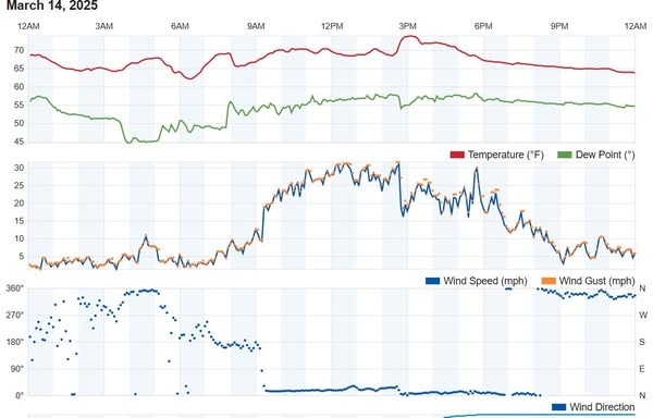
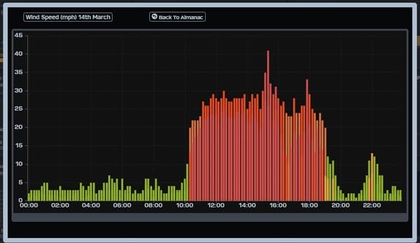
Nerd Note: For much of the afternoon yesterday, area wind graphs at Rasta Beach and the campground (see below) showed relatively steady winds of around 20-24 mph (note that the Rasta Beach gauge plots 1-minute sustained winds as opposed to the 10-minute average at the campground, so winds are typically 4-5 mph higher there). Then around 2:30 things started to get really weird. The solid NE flow at Rasta rapidly shifted to due north, and wind speeds dropped like a rock (personal observation). At the campground, winds increased dramatically at around 3 pm, then peaked with a wind gust of 41 mph at 3:20 pm… the highest wind gust of the season. A surge in the west component of the winds at Rasta was likely the cause of the dramatic change there, but I don’t have a good explanation of why the campground recorded such a high wind gust.
¡Buenos dias! A satellite pass last evening measured light and variable winds over much of the southern Sea of Cortez, however all of the latest numerical model forecasts show solid north to north-northwest background flow establishing itself by around midday today. Another sunny day is ahead, so we will see a strong thermal boost as well. The remainder of the forecast looks on track as model forecasts are in good agreement that we’ll see a light wind day on Monday, then north flow returns again Tuesday afternoon. Norte conditions still look likely on Wednesday as surface high pressure builds into the western U.S., with solid north flow continuing through Thursday.
Today…Sunny. North wind 20-24 mph.
Saturday…Sunny. North wind 20-24 mph.
Sunday…Mostly sunny. North wind 18-22 mph.
Monday…Sunny. Northeast wind 12-14 mph.
Tuesday…Sunny. North wind 16-20 mph.
Wednesday…Mostly sunny. North wind 22-26 mph and gusty.
¡Buenos dias! Today is going to be one of the more interesting days of the season to watch unfold, as it is shaping up to be a classic battle between a fairly strong west to northwest background flow and our local thermal (see nerd note below). All of the latest numerical model forecasts show the east-west oriented ridge of high pressure that was located to our north yesterday and gave us that spectacular afternoon of steady north wind yesterday has been nudged to the south this morning by a storm system over California. This has resulted in the background flow becoming much more westerly, and model forecasts show a significant west component is likely to continue through today. That said, we will see full sunshine today, and with the strong March sun, we could see our local thermal overpower the west wind component and draw the winds onshore. It is going to be very, very close, so my best advice is to be ready. Model forecasts are in excellent agreement that the ridge of high pressure over BCS will move northward on Friday, with the background flow becoming more northerly here. Solid north flow if forecast to continue through the upcoming weekend, then rapidly diminish on Monday as another storm system moves into California. North flow is then forecast to return as early as Tuesday afternoon, then as as strong surface high builds into the western U.S. on Wednesday, long-range model forecasts show norte conditions developing here.
Today…Sunny. North to northwest wind 16-20 mph(?).
Friday…Sunny. North wind 20-24 mph.
Saturday…Sunny. North wind 20-24 mph.
Sunday…Mostly sunny. North wind 18-22 mph.
Monday…Sunny. Northeast wind 12-14 mph.
Tuesday…Sunny. North wind 16-18 mph.
Wednesday…Mostly sunny. North wind 22-26 mph and gusty.
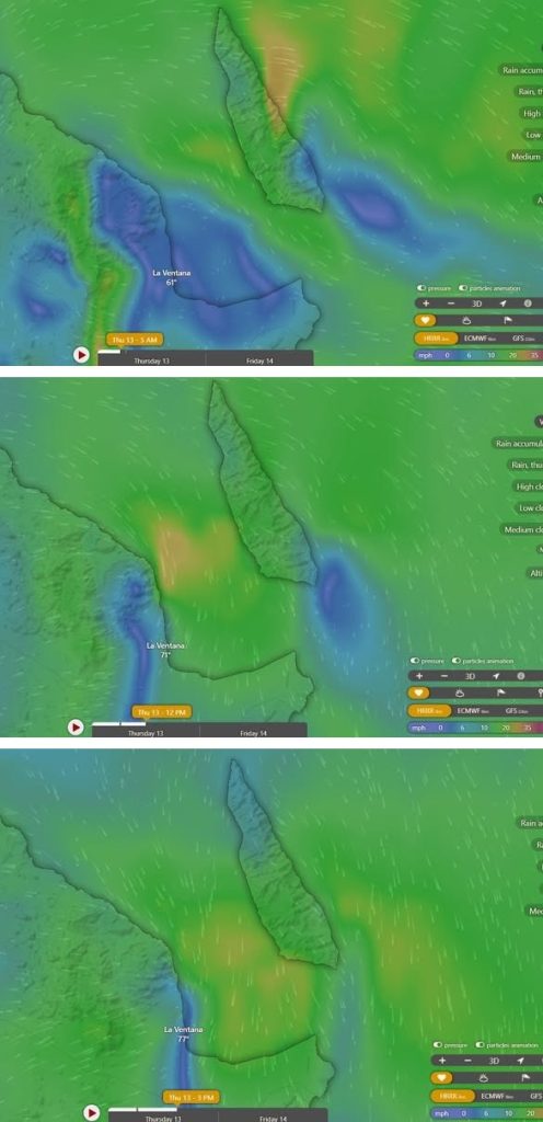
Nerd Note: Numerical weather prediction has seen spectacular advancements over the last 100 years, particularly in the last 70 years, and computer models now have the ability to resolve relatively small-scale weather phenomena. One such model, the High Resolution Rapid Refresh model (HRRR), run by NOAA’s National Center for Environmental Prediction in Washington, D.C., has a horizontal resolution of 3 kilometers and has the capacity to at least partially resolve some of the more important features which drive our local wind machine. Below are a series of graphics showing the HRRR forecasts for wind today over Ventana Bay. Notice the westerly component just before sunrise is shadowed by the Cacachilas Mountains to our west, with only light winds over the bay. By noon the local thermal has drawn much of the west component out of the background flow and the model shows solid north winds coming onshore. By 3 pm, the model forecast shows the background west flow overwhelming the local thermal and driving the north flow offshore. It’ll be interesting to watch how this actually plays out today.
¡Buenos dias! An Oceansat satellite pass around midnight measured west winds at around 5 knots near Cerralvo, but all of the latest numerical model forecasts show a narrow ridge of high pressure will form to our north today and bring us a fresh pulse of north background flow. Infrared satellite loops early this morning showed clear skies will again be the rule today, so we will see a good thermal bump as well. The forecast becomes a lot trickier tomorrow as a storm system tracks from west to east across far southern California and the northern Baja Peninsula and tends to nudge the ridge of high pressure located to our north southward. This will turn the background flow more westward, and it’ll be close to see if our strong March thermal will be enough to pull the winds onshore Wednesday afternoon. For now it looks like the southern beaches will have the best chance of seeing sideshore winds, with NNW wind-shadowed and gusty conditions likely on northern beaches. Model forecasts are in excellent agreement that the ridge of high pressure over BCS on Thursday will move northward again on Friday with solid north background flow returning to our region. Similar conditions are expected on Saturday, then a reinforcing shot of high pressure will build into the 4-corners region of the U.S. on Sunday and ensure another windy day here. Long-range model forecasts are in good agreement that rapid changes will take place on Monday, with another storm system impacting California and the background flow over BCS becoming weak. As the storm system far to our north continues moving eastward on Tuesday, Pacific high pressure will begin building back into the Baja Peninsula, with north flow possibly reaching us as early as Tuesday afternoon.
¡Buenos dias! The wind gauge at Rasta yesterday showed north winds of 12-14 mph from around 1:30-2:30, and some of us got a feeble few runs in before the dreaded easterlies shut it down. An Oceansat satellite pass around midnight measured light southerly winds east of Cerralvo, and all of the most recent numerical model forecasts show light onshore breezes will develop this afternoon. A surface low pressure system west of Ensenada this morning will move inland on Wednesday and allow a narrow ridge of high pressure to build into the central Baja Peninsula. This will bring north background flow back to our region, and with sunny skies expected, we will see a good thermal boost as well. Another storm system will affect California and the far northern Baja Peninsula on Thursday, and tend to nudge the surface ridge located just to our north a bit farther south. This will add a westerly component to the background flow on Thursday, but models show the background flow veering to a more northerly direction during the afternoon. Models are in excellent agreement that the large surface high over the eastern Pacific will build eastward into the northern Baja Peninsula on Friday, with increasing north background flow here. Solid north flow will likely continue through Saturday, then increase a bit on Sunday as a reinforcing shot of high pressure builds into the 4-corners region of the U.S. Long-range forecasts show north flow decreasing on Monday as another storm system moves into the western U.S. from the Pacific.
¡Buenos dias! An Oceansat satellite pass around midnight measured NW winds of 10-15 knot just east of Cerralvo, but all of the latest forecast model runs show the background NW flow will weaken substantially today and fall to near or just below the lower threshold to fully activate our local wind machine. It’ll be close, and with full sunshine expected, we may see rideable wind this afternoon especially on the northern beaches. Tuesday still looks like a light onshore day as the surface pressure gradient over BCS remains very weak. Surface high pressure is then forecast to build into the Baja Peninsula from the eastern Pacific on Wednesday, with north flow returning. It now appears that the ridge of high pressure will likely set up just far enough north of us so that north…northwest background flow will continue on Thursday. Models are in good agreement that the ridge will then remain firmly in place Friday through the upcoming weekend, with solid north flow continuing. There may be some thin, high cloud cover on Friday, but otherwise we will see lots of sun and good thermal boosts each day.
Buenos dias! The first day of the norte didn’t have quite the bite that I though it would, as 10 minute sustained winds at the campground yesterday peaked at 22 mph around noon then hovered around 20 mph for the remainder of the day. As predicted by the models the norte peaked overnight, and an evening ASCAT pass measured a large area of 25 knot NNW winds over the Sea of Cortez from just north of La Paz northward to just north of Mulege, with 20 knot winds sampled just east of Cerralvo. Local wind gauges with clear western exposures were measuring occasional NW gusts into the mid 20s early this morning. The latest batch of model forecasts show the norte diminishing this afternoon, but moderate north flow will continue and combine with abundant sunshine to bring us a windy afternoon. Model forecasts are in good agreement that as a surface low approaches southern California on Monday the background flow here will fall to just below the threshold to fully activate our local wind machine. That said it’ll be close, and with full sunshine again expected, we may see a bonus day so best be prepared. Light onshore flow looks likely for Tuesday as the low far to our north moves onshore and the surface pressure gradient over BCS remains weak. Surface high pressure in the eastern Pacific is then forecast to build eastward into the Baja Peninsula on Wednesday and bring a fresh pulse of north flow to the southern Sea of Cortez. Another Pacific storm system will affect California on Thursday and tend to nudge the ridge of high pressure located just to our north southward a bit, and several of the forecast models show our background flow becoming northwest as as result. As the storm system far to our north tracks eastward into the central plains of the U.S. on Friday, surface high pressure from the eastern Pacific is once again forecast to build eastward into BCS with north flow returning and lasting into the weekend.