La Ventana Stories

Wind – December 27, 2024

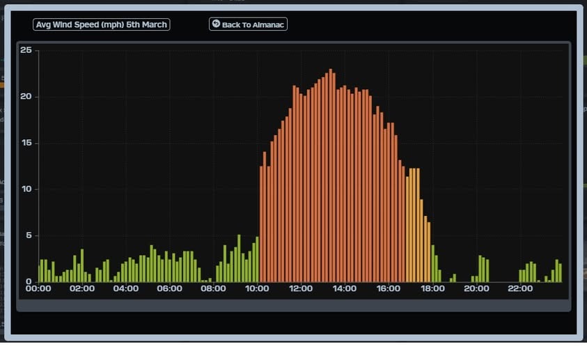
¡Buenos dias! The wind gauge at the campground yesterday showed an unusual stairstep pattern, with sustained winds of 14-16 mph from around 10 am until 2 pm, then a bump to 16-18 mph from 2 until 3:30, then a final bump to 19-20 mph from 3:40 until 4:40 (see image below). Several of the latest model forecasts show the background flow peaking at 3-4 pm this afternoon, so we may see another day of rigging changes. Models show a similar pattern of a mid-late afternoon peak in winds on Saturday, with slightly stronger winds possible. The surface high anchored far to our north should remain in place on Sunday, giving us one more rideable day. All of the forecast models indicate that we’ll get a rest day on Monday, as the surface pressure gradient over BCS becomes very weak. Surface high pressure will begin building back into the interior west of the U.S. on Tuesday, and we should see north background flow increase just enough to help jump start our local wind machine. As the surface high continues to build to the southeast on Wednesday, models show our background north flow increasing substantially, with moderate to strong flow continuing into Thursday.

  • Today…Mostly sunny. North wind increasing to 16-20 mph by mid afternoon.
  • Saturday…Sunny. North wind 18-22 mph.
  • Sunday…Sunny. North wind 16-20 mph.
  • Monday…Sunny. North wind 10-12 mph.
  • Tuesday…Sunny. North wind 16-18 mph.
  • Wednesday…Sunny. North wind 18-22 mph.
  • Thursday…Sunny. North wind 18-22 mph.

Wind – December 26, 2024

¡Buenos dias! One of the ASCAT satellites showed the leading edge of a new pulse of north wind had made it as far south as Loreto, and all of the new model forecasts show solid north background flow returning to our area today. Infrared satellite loops early this morning again showed clear skies over BCS, so we’ll see our local thermal in fine form this afternoon. Surface high pressure is forecast to remain locked-in over the southwestern U.S. through Sunday, with ample north flow continuing. Another stretch of sunny skies is also likely, so we’ll see good thermal boosts each day. Models are in good agreement that the surface pressure gradient will weaken substantially on Monday, and the background north flow will likely become too weak to fully activate our local wind machine. While long-range forecasts disagree on the timing, they all show Pacific high pressure will build back into the interior west as early as Tuesday and send a fresh pulse of north wind into the southern Sea of Cortez. Extended-range forecasts are in good agreement that surface high pressure will again remain parked over the southwestern U.S. for several days and give us solid north flow though next week.

  • Today…Sunny. North wind 18-22 mph.
  • Friday…Sunny. North wind 16-20 mph.
  • Saturday…Sunny. North wind 16-20 mph.
  • Sunday…Sunny. North wind 16-20 mph.
  • Monday…Sunny. North wind 10-12 mph.
  • Tuesday…Sunny. North wind 16-20 mph.
  • Wednesday…Sunny. North wind 18-22 mph.

Wind – December 25, 2024

Twas the morning of Christmas
And all through the bay
Wind junkies were hoping
For one more good day
The satellites last evening
Showed winds were too light
Over the Sea of Cortez
To fly even a big kite
The new runs show light flow
Is likely to stay
So trying new presents
Must wait one more day
High pressure tomorrow
Is forecast to move
Into the western U.S.
And get us back in the groove
North winds will be blowing
On Thursday by 1
So our rest will be short
It’s time for more fun
Good flow should continue
Through Sunday at least
As high pressure holds steady
And we enjoy the wind feast
Winds will then become light
By Monday or so
As the gradient gets weak
And north winds fail to blow
Looking into the future
The models agree
That next week may get windy
We’ll just have to see
But one thing is certain
As we start a new day
We’re so lucky to be here
In this beautiful bay
Feliz Navidad from MasViento!

  • Christmas Day…Sunny. East wind 8-10 mph.
  • Thursday…Sunny. North wind 16-20 mph.
  • Friday…Sunny. North wind 16-20 mph.
  • Saturday…Sunny. North wind 16-20 mph.
  • Sunday…Sunny. North wind 16-20 mph.
  • Monday…Sunny. North wind 10-12 mph.
  • Tuesday…Sunny. North wind 16-18 mph.

Wind – December 24, 2024

¡Buenos dias! An ASCAT pass last evening measured light and variable winds over the Sea of Cortez east of Cerralvo. Almost all of the latest model forecasts show a ridge of high pressure will build into the central Baja Peninsula today and produce just enough north flow over our region to once again fully engage our local wind machine. Infrared satellite loops show sunny skies will be the rule today, so we should see a good thermal bump as well. Models are in excellent agreement that Christmas Day will see only light onshore breezes, as the surface pressure gradient over BCS becomes very weak. It will be a brief break however, as surface high pressure is forecast to once again build into the southwestern U.S. on Thursday and push an new pulse of north wind into the southern Sea of Cortez. The surface high will likely remain nearly stationary through the upcoming weekend, with steady north background flow and sunny skies expected through Sunday. Long-range model forecasts show the surface pressure gradient becoming week next Monday, with winds becoming light.

  • Today…Sunny. North wind 16-18 mph.
  • Christmas Day…Sunny. East wind 8-10 mph.
  • Thursday…Sunny. North wind 16-18 mph.
  • Friday…Sunny. North wind 16-20 mph.
  • Saturday…Sunny. North wind 16-20 mph.
  • Sunday…Sunny. North wind 16-20 mph.
  • Monday…Sunny. North wind 10-12 mph.

Wind – December 23, 2024

¡Buenos dias! An ASCAT pass last evening measured NW winds around 10 knots over the Sea of Cortez just to our east, and almost all of the latest forecast model runs show the background flow today will fall below the lower threshold to fully trigger our local wind machine. That said…the ECMWF model, which has proven to be fairly accurate in similar situations, is showing a pulse of north flow forming by mid afternoon, and if this happens, we may see a couple of hours of kiteable winds. My best advice for those that aren’t ready for a rest day…be ready just in case. The vast majority of model forecasts continue to indicate that we’ll see a pulse of north flow on Tuesday as a weak ridge of high pressure forms just to our north, and with sunny skies expected, it should be enough to bring us a windy afternoon. Christmas Day looks to be a down day as surface low pressure tracking far to our north creates a light wind regime over BCS. A relatively weak surface high will build into the southwestern U.S. on Thursday, and this should tighten the surface pressure gradient over BCS just enough to bring us a fresh pulse of north background flow. Models are in good agreement that the surface high will remain anchored over the southwestern U.S. through the upcoming holiday weekend, with solid north background flow continuing here.

  • Today…Sunny. North wind 12-14 mph, maybe more?
  • Tuesday…Sunny. North wind 16-18 mph.
  • Christmas Day…Sunny. East wind 8-10 mph.
  • Thursday…Sunny. North wind 16-18 mph.
  • Friday…Sunny. North wind 16-20 mph.
  • Saturday…Sunny. North wind 18-22 mph.
  • Sunday…Sunny. North wind 16-20 mph.

Wind – December 22, 2024

¡Buenos dias! There were no scatterometer satellite passes last night, but the most recent model forecasts indicate that although the surface high to our north has weakened, we will likely see just enough background north flow remaining today to give us one more good day. Infrared satellite loops early this morning showed another sunny day ahead, so we’ll likely see another solid thermal boost this afternoon. Models show the surface pressure gradient will become weak tomorrow, and it now appears unlikely that we will see a rideable day for most folks. A weak ridge of high pressure is still forecast to form just to our north on Tuesday, and this should give us just enough of a bump in north background flow to help trigger a good afternoon. Surface low pressure will track across the southwestern U.S. on Christmas Day, and as a result our winds will likely become light and variable. Relatively weak surface high pressure will then build back into the interior west of the U.S. on Thursday, and some of the model forecasts show that we’ll see just enough north flow to trigger our wind machine Thursday into Friday. Long-range forecasts indicate the surface high centered far to our north strengthening on Saturday, with winds increasing here.

  • Today…Sunny. North wind 16-20 mph.
  • Monday…Sunny. North wind 12-14 mph.
  • Tuesday…Sunny. North wind 16-18 mph.
  • Christmas Day…Sunny. East wind 8-10 mph.
  • Thursday…Sunny. North wind 16-18 mph.
  • Friday…Sunny. North wind 16-18 mph.
  • Saturday…Sunny. North wind 18-22 mph.

Wind – December 21, 2024

¡Buenos dias! Two ASCAT satellites measured widespread 10-15 knot NNW winds over the southern Sea of Cortez last evening, and again the latest model forecasts show another great day ahead. Surface high pressure that has been anchored over the interior west of the U.S. will begin to weaken on Sunday, but there will still be ample north background flow, and with another sunny day ahead, we’ll likely see one more windy day. Models are in good agreement that the surface pressure gradient will become weak over BCS on Monday, with the background flow falling to just below the critical threshold for helping fully trigger the La Ventana wind machine. That said, it’ll be close, and some may be able to get a couple of hours of rideable wind. A weak surface ridge is forecast to form just to our north on Tuesday, and this feature should give us enough of a bump in the north flow to produce a windy afternoon. Models are still in good agreement that we’ll see a down day for Christmas as surface low pressure tracks from west to east across the southwestern U.S. and our flow becomes weak. Most of the long-range forecasts show surface high pressure again building to our north on Thursday, and we’ll likely see a return of solid north winds on Thursday lasting at least through Friday. Extended forecasts are looking encouraging moving into the New Year’s holiday as a blocking pattern along the west coast of the U.S. reestablishes itself and surface high pressure builds to our north. If this verifies we could see another long stretch of classic La Ventana days into the beginning of the New Year.

  • Today…Sunny. North wind 18- 22 mph.
  • Sunday…Sunny. North wind 16-20 mph.
  • Monday…Sunny. North wind 14-16 mph.
  • Tuesday…Sunny. North wind 16-18 mph.
  • Christmas Day…Sunny. East wind 8-10 mph.
  • Thursday…Sunny. North wind 16-20 mph.
  • Friday…Sunny. North wind 16-20mph.

Wind – December 20, 2024

¡Buenos dias! There were no wind-measuring satellite passes last evening over BCS, but all of the most recent model forecasts show solid north background flow will continue today. North flow will slowly weaken Saturday into Sunday, but there should be enough remaining to give us rideable days through the weekend. Our amazing stretch of sunny days will also continue, so we should see good thermal boosts each day as well. Monday still looks to be marginal, as north background flow falls to near of just below the threshold for fully activating our local wind machine. Several model forecasts continue to indicate a bump up in the north background wind on Tuesday, then we will likely see a down day on Wednesday as surface low pressure tracks from west to east far to our north and our winds become light. The long-range model forecasts disagree, but a couple of them show a return of sufficient north flow on Thursday to give us a rideable day.

  • Today…Sunny. North wind 18-22 mph.
  • Saturday…Sunny. North wind 16-20 mph.
  • Sunday…Sunny. North wind 16-18 mph.
  • Monday…Sunny. North wind 14-16 mph.
  • Tuesday…Sunny. North wind 16-18 mph.
  • Christmas Day…Sunny. East wind 8-10 mph.
  • Thursday…Sunny. North wind 16-18 mph.

Wind – December 19, 2024

¡Buenos dias! The wind party just keeps on coming, as the wind gauge at the campground yesterday recorded 4 solid hours of 20-24 mph sustained winds. An ASCAT pass last evening measured NNW winds at 10-15 knots over the southern Sea of Cortez, and with satellite loops showing only a few high clouds to our east early this morning, we will see another big thermal boost this afternoon. Model forecasts show the surface high pressure to our north that has been responsible for this latest stretch of perfection will remain in place through Sunday and only gradually weaken, and with sunny skies expected, our amazing streak of windy days will likely continue through the weekend. Model forecasts are in good agreement that the surface pressure gradient over BCS will weaken on Monday, with background north flow here falling to near the lower threshold to fully activate our local wind machine. We may see a slight bump in the background flow on Tuesday, but as low pressure moves through the southwestern U.S. on Christmas Day, winds here will likely become light.

  • Today…Sunny. North wind 18-22 mph.
  • Friday…Sunny. North wind 16-20 mph.
  • Saturday…Sunny. North wind 16-20 mph.
  • Sunday…Sunny. North wind 16-18 mph.
  • Monday…Sunny. North wind 14-16 mph.
  • Tuesday…Sunny. North wind 16-18 mph.
  • Christmas Day…Sunny. East wind 8-10 mph.

Wind – December 18, 2024

¡Buenos dias! An ASCAT satellite pass late last evening measured NW winds of 10-15 knots over the southern Sea of Cortez near Cerralvo, and the most recent batch of numerical model forecasts all show the north background flow will increase today. Surface high pressure centered over Colorado early this morning will build southward into the 4-corners region of the U.S. and this will cause the surface pressure gradient over BCS to tighten. The surface pressure gradient is forecast to loosen a bit on Thursday, but our most recent run of incredible days will continue through at least Sunday, as high pressure remains in place over the interior west of the U.S. and full sunshine each day produces a good thermal boost. Long-range model forecasts show the surface high weakening on Monday, with lighter winds likely into Tuesday.

  • Today…Sunny. North wind 20-24 mph.
  • Thursday…Sunny. North wind 16-20 mph.
  • Friday…Sunny. North wind 16-18 mph.
  • Saturday…Sunny. North wind 16-20 mph.
  • Sunday…Sunny. North wind 16-18 mph.
  • Monday…Sunny. North wind 14-16 mph.
  • Tuesday…Sunny. North wind 14-16 mph.