La Ventana Stories

Wind – February 10, 2025

¡Buenos dias! Satellite passes last evening measured northwest winds of around 5 knots over the southern Sea of Cortez, and model forecasts show the surface pressure gradient remaining very weak today with light background flow and only light onshore breezes expected. The overall weather picture for the next week remains on track, with Pacific high pressure forecast to begin building into the Baja Peninsula on Tuesday. The axis of the surface high will likely be just south of us on Tuesday, with a significant west component to the background flow. Model forecasts are in good agreement that the E-W oriented ridge of high pressure will move northward a bit on Wednesday, and this should help turn the background flow to a more northerly direction here. Similar conditions are forecast to continue Thursday and Friday, with sufficient north background flow and ample sunshine to help jump start our local wind machine. Long-range model forecasts indicate that surface high pressure will build into the western U.S. and give us an added boost of north flow on Saturday, with solid north flow and ample sunshine continuing through next weekend.

  • Today…Mostly sunny. East wind 8-10 mph.
  • Tuesday…Partly sunny. Northwest wind 8-10 mph.
  • Wednesday…Sunny. North wind 16-18 mph.
  • Thursday…Sunny. North wind 16-18 mph.
  • Friday…Sunny. North wind 16-18 mph.
  • Saturday…Sunny. North wind 18-22 mph.
  • Sunday…Mostly sunny. North wind 18-22 mph.

Wind – February 9, 2025

¡Buenos dias! A couple of scatteremeter satellite passes last evening measured light and variable winds and it doesn’t look good according to the newest run of numerical model forecasts for our background flow today. That said, there are some hints in a couple of the models that show the light north background flow hovering at a level just below the typical threshold we see for initiating our local wind machine, so winds could increase a bit and even give the north beaches a couple of hours of marginal winds for this afternoon. The light winds will continue as models are showing a very weak surface pressure gradient tomorrow with only light onshore breezes expected. Surface high pressure will begin to build into the Baja Peninsula from the eastern Pacific on Tuesday, with west to northwest flow increasing. As we discussed yesterday, going into the middle of the week our winds will depend on exactly where an east-west ridge of high pressure sets up over BCS. The latest model runs are in good agreement that the ridge axis will be just to our north, and if this verifies, we will see ample north background flow from Wednesday through Friday. Sunny skies are also expected, so we will likely see a good thermal boost each day. Long-range models show surface high pressure building over the interior west of the U.S. on Saturday, with solid north flow continuing through next weekend.

  • Today…Sunny. Northeast wind 10-12 mph.
  • Monday…Mostly sunny. East wind 8-10 mph.
  • Tuesday…Mostly sunny. Northwest wind 12-14 mph.
  • Wednesday…Sunny. North wind 16-20 mph.
  • Thursday…Sunny. North wind 16-20 mph.
  • Friday…Sunny. North wind 16-20 mph.
  • Saturday…Mostly sunny. North wind 18-22 mph.

Wind – February 8, 2025

¡Buenos dias! An Oceansat satellite pass late last evening measured NW winds of 10 knots over the southern Sea of Cortez, and all of the latest numerical model forecasts show the background flow decreasing a bit today. It’ll be close again, but it looks like there will be just enough north flow remaining to help trigger our wind local machine. Infrared satellite loops early this morning showed some patches of high cloud streaming in from the southwest, but model forecasts indicate that we will likely see plenty of sun this afternoon, so we should see a significant thermal boost. The surface pressure gradient is forecast to weaken further on Sunday, with light winds expected here as a result. Similar conditions will likely persist through Monday with only light onshore breezes expected. Model forecasts are in good agreement that surface high pressure over the eastern Pacific will build eastward slightly into the Baja Peninsula on Tuesday, and depending on where the E-W oriented ridge sets up, we could see either too much west in the background flow if the ridge is too close to us or good north flow if it sets up farther to our north. For now, it looks like there will be a substantial west component to the winds on Tuesday, but Wednesday may see the flow becoming more northerly. Long-range models show similar uncertainty in the position of the ridge of high pressure for Thursday and Friday, but for now I’ll be optimistic that the axis of the ridge will be just to our north and we’ll see ample north background flow.

  • Today…Mostly sunny. North wind 16-18 mph.
  • Sunday…Sunny. Northeast wind 10-12 mph.
  • Monday…Sunny. East wind 8-10 mph.
  • Tuesday…Mostly sunny. North…northwest wind 12-14 mph.
  • Wednesday…Mostly sunny. North wind 16-18 mph.
  • Thursday…Mostly sunny. North wind 16-20 mph.
  • Friday…Mostly sunny. North wind 16-18 mph.

Wind – February 7, 2025

¡Buenos dias! Yesterday was a great example of just how sensitive our local wind machine is to the strength of the background flow. As I mentioned in yesterday’s discussion, the model forecasts showed winds just below the threshold to fully trigger it, but as those of us that were at Rasta yesterday know, while winds struggled to exceed the 10-12 mph range early in the afternoon, winds increased to around 16 mph from around 1:30-3:30, with higher winds farther north towards playa aguas calientes (personal observation). The wind gauge at the campground showed another light wind day, with only 10-12 mph sustained winds. Just a couple mph increase in the background flow can make a world of difference and sometimes bring us a great bonus day. The latest model forecasts are spreading the wind love to the entire bay today, as surface high pressure in the eastern Pacific builds into BCS. Ample background flow will likely last through Saturday, and with sunny skies expected, we should see another good thermal boost. Model forecasts are in good agreement that the surface pressure gradient will become very weak over our region on Sunday, with light background flow the result. Similar conditions are expected on Monday, then surface high pressure will begin to build back into BCS on Tuesday, but at this point models show a significant west component to the wind. Long-range forecasts are in good agreement that ample north flow will return on Wednesday and may last through the following weekend.

  • Today…Sunny. North wind 16-20 mph.
  • Saturday…Sunny. North wind 16-18 mph.
  • Sunday…Sunny. Northeast wind 10-12 mph.
  • Monday…Mostly sunny. East wind 8-10 mph.
  • Tuesday…Mostly sunny. Northwest wind 10-12 mph.
  • Wednesday…Sunny. North wind 16-20 mph.
  • Thursday…Mostly sunny. North wind 16-20 mph.

Wind – February 6, 2025

¡Buenos dias! Satellite-derived winds of 5-10 knots were noted east of Cerralvo early this morning, but all of the latest model forecasts show the background flow today will be just below the threshold for fully activating our wind machine…less than we saw yesterday when northern beaches had a beautiful thermal. Surface high pressure is forecast to build into the Baja Peninsula on Friday and give us a bump in north flow which may last through Saturday. Light winds are forecast to return on Sunday as the surface pressure gradient again becomes weak. Light winds will likely last through Monday, then there are indications we may see another slight increase in north flow on Tuesday. While long-range models disagree, an active storm track across California may form by the middle of next week and bring us a light wind regime.

  • Today…Sunny. Northeast wind 10-12 mph.
  • Friday…Sunny. North wind 16-20 mph.
  • Saturday…Sunny. North wind 16-18 mph.
  • Sunday…Sunny. Northeast wind 10-12 mph.
  • Monday…Partly sunny. East wind 8-10 mph.
  • Tuesday…Mostly sunny. North wind 16-18 mph.
  • Wednesday…Mostly sunny. Northwest wind 10-12 mph.

Wind – February 5, 2025

¡Buenos dias! An ASCAT satellite pass last evening measured light and variable winds over the southern Sea of Cortez. The forecast for the next 2 days is a low-confidence one, as the latest numerical model runs continue to show the background north flow over our area will be at or just below the lower threshold for triggering our wind machine. There are some indications that we may get a slight increase in the north flow today, and it looks like northern beaches will have the best chance to see kiteable winds this afternoon. Models show the background north flow remaining very near the lower threshold tomorrow, so it’ll likely be another nail-biter. The surface pressure gradient is forecast to tighten a bit on Friday, and this will likely bring the best chance for a windy afternoon for the next several days. Model forecasts are in good agreement that the surface pressure gradient will again become very weak on Saturday, with similar conditions lasting into Monday. Long-range forecasts show some hope of significant north flow returning on Tuesday.

  • Today…Sunny. North wind 16-18 mph (north beaches).
  • Thursday…Sunny. North wind 14-16 mph (north beaches).
  • Friday…Sunny. North wind 16-20 mph.
  • Saturday…Sunny. Northeast wind 10-12 mph.
  • Sunday…Sunny. Northeast wind 8-10 mph.
  • Monday…Partly sunny. Northeast wind 8-10 mph.
  • Tuesday…Mostly sunny. North wind 16-18 mph.

Wind – February 4, 2025

¡Buenos dias! Northern beaches got a nice bonus day yesterday as sustained winds peaked at around 16 mph from 3-4 pm, while southern beaches only saw 10-12 mph with a 20 minute peak of 13 mph.

An ASCAT satellite pass last evening measured light and variable winds over the southern Sea of Cortez, and the latest model forecasts show only light ENE winds for much of the bay this afternoon. For folks jonesing for another light wind session, it may be a summer-like day at La Bufadora where winds could peak at 12-14 mph from around 12-2 pm. The forecast for Wednesday and Thursday remains a low-confidence one, as the background flow flirts with the lower threshold to fully jump-start our local wind machine. Full sunshine will help the cause, and at this point several of the more reliable models indicate it’ll be a go so I’ll continue to be optimistic. Surface high pressure over the eastern Pacific is forecast to build into the Baja Peninsula a bit on Friday, with better chances of solid north background flow. The models then disagree on whether we’ll see sufficient north flow continuing through the weekend, but again a couple of the more reliable models say yes. Long-range models show surface low pressure may form over the southwestern U.S. by Monday, with winds becoming lighter here.

  • Today…Sunny. East wind 8-10 mph.
  • Wednesday…Sunny. Northeast wind 16-18 mph.
  • Thursday…Sunny. North wind 16-18 mph.
  • Friday…Sunny. North wind 16-20 mph.
  • Saturday…Sunny. North wind 16-18 mph.
  • Sunday…Sunny. North wind 16-20 mph.
  • Monday…Mostly sunny. Northeast wind 14-16 mph.

Wind – February 3, 2025

¡Buenos dias! An ASCAT satellite pass last evening measured WNW winds of 5 to 10 knots over the Sea of Cortez just east of Cerralvo, and model forecasts show the background flow will likely be just below the lower threshold for fully triggering our local wind machine today. Infrared satellite loops early this morning showed an area of thin, high clouds streaming into BCS from the west, and these will likely partially dampen our local thermal as well. That said, it’ll be very close, and the High Resolution Rapid Refresh (HRRR) model shows marginally kiteable wind (12-14 mph?) along the northern beaches for a couple of hours early this afternoon. Model forecasts are in excellent agreement that we will see very light background flow on Tuesday, with only light onshore breezes expected. The forecast for Wednesday and Thursday remains a low-confidence one, as the models show the background flow will be very near the threshold we need for kiteable winds, but at this point I will continue to be optimistic. Sunny skies will be in our favor both days, so if we are lucky we may see things come together. The latest model runs are in good agreement that surface high pressure over the eastern Pacific will build into BCS on Friday and increase the north flow over our area. At this point it looks like solid north flow will continue through next weekend, and with sunny skies expected, we should see good thermal boosts each day. Looking farther into the future, both the European and American long-range forecasts show a favorable weather pattern setting up for sufficient north flow into the middle of February, so our AMAZING 2024-25 season looks like it may continue (see graph below).

  • Today…Mostly sunny. Northeast wind 10-12 mph.
  • Tuesday…Mostly sunny. East wind 8-10 mph.
  • Wednesday…Sunny. Northeast wind 16-18 mph.
  • Thursday…Sunny. North wind 16-18 mph.
  • Friday…Sunny. North wind 16-20 mph.
  • Saturday…Sunny. North wind 16-20 mph.
  • Sunday…Sunny. North wind 18-22 mph.

Oarfish Rescue Video Series & Beaching Awareness Project

What’s an Oarfish you may ask? Here’s what they look like.

Oarfish are rare deep-water filter feeders that live at depths of 600-3000ft. and grow as long as 36-feet. Sometimes, they get beached along the shoreline. I’ve had two encounters where I swam each fish out to sea, as documented in Oarfish Rescue (Spanish: Recate de un pez remo) and Swimming with Oarfish (Spanish: Nadando con los peces remo). In both, the behavior of this fish is on full display as it responds to and navigates a shallow water environment. Very little is known about this fish, but by observing their behavior in these videos, we learn more about them, and can attempt to answer the most common, basic question at the center of the great mystery surrounding this interesting, one-of-a-kind fish; “Why do Oarfish get stranded on our beaches?”

A third video How to Rescue an Oarfish (Spanish: Cómo recatar un pez remo) instructs how to save an Oarfish without harming it, drawing on experience, using footage from two rescues, introducing how/where to report an Oarfish beaching. At the end, see photos of a beaching that took place 21-years ago in El Sargento when a 14.5 foot Oarfish landed on the very same beach where the aforementioned videos were filmed. 

Oarfish videos in Spanish:

Here’s the link to a playlist of all videos in English and Spanish: Entire Playlist-Oarfish Rescue Series – English and Spanish.

Here are two poster links in Spanish and English announcing “The Oarfish Beaching Awareness Project” whose goal it is assist those who want to help beached Oarfish, and to provide information on how/where to report stranded Oarfish. This data will help us determine the location and frequency of Oarfish beachings, and help us learn more about this amazing fish. 

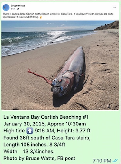
We received our first 2025 Oarfish beaching report,  when a stranded Oarfish died along La Ventana Bay. See the report below. A thank you to Bruce Watts  for taking the photo!

It is my hope that the learning we do together will somehow benefit this unique and special deep-water fish.

Thank you, William Ihne  – Oarfish Beaching Awareness Project Coordinator.

To report a beaching: 52 612 204 5156 WhatsApp, desertplayer@hotmail.com

Wind – February 2, 2025

¡Buenos dias! The surface high centered to our northwest that has brought us the latest very windy streak has weakened, and an Oceansat satellite pass around midnight confirmed that the NNW background flow had diminished to around 10 knots. The latest model forecasts all show similar background winds for this afternoon, and infrared satellite loops early this morning indicated another sunny day ahead so we will likely see a solid thermal boost. The eastern Pacific surface high is forecast to weaken further on Monday, and all of the models show the background flow falling below the threshold that typically would help jump start our local wind machine. Similar light background flow is forecast to continue on Tuesday, with only light onshore breezes expected during the afternoon. The forecast for Wednesday through Saturday is a tricky one, as most of the latest model guidance shows the east Pacific high pressure system strengthening just enough to increase our north background flow a bit, and with sunny skies expected through the period, we could see kiteable winds each day. For now I’ll be optimistic but confidence is low.

  • Today…Sunny. North wind 16-20 mph.
  • Monday…Mostly sunny. Northeast wind 10-12 mph.
  • Tuesday…Mostly sunny. East wind 8-10 mph.
  • Wednesday…Sunny. Northeast wind 16-18 mph.
  • Thursday…Sunny. North wind 16-18 mph.
  • Friday…Sunny. North wind 16-18 mph.
  • Saturday…Sunny. North wind 16-18 mph.