La Ventana Stories

Wind – February 3, 2025

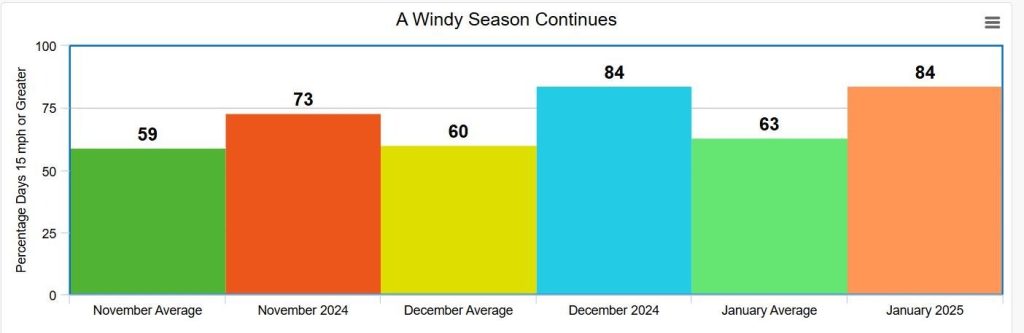
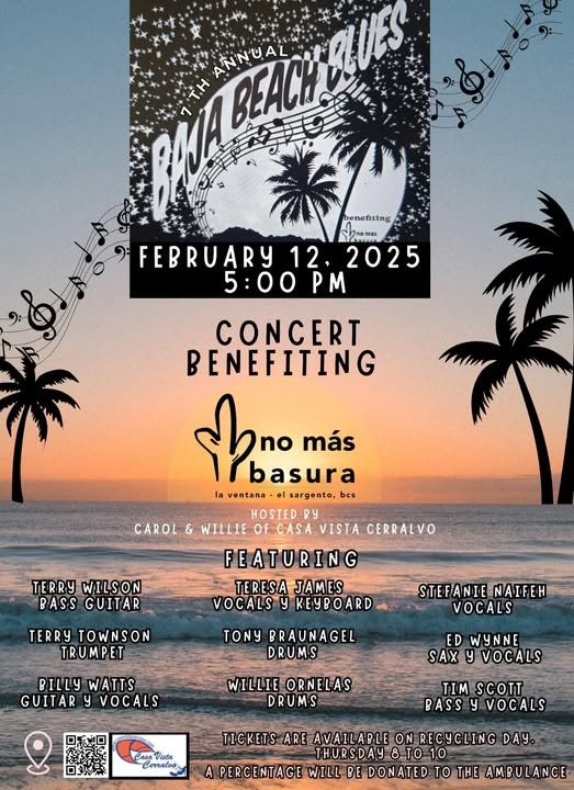
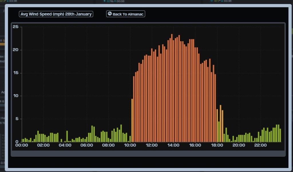
¡Buenos dias! An ASCAT satellite pass last evening measured WNW winds of 5 to 10 knots over the Sea of Cortez just east of Cerralvo, and model forecasts show the background flow will likely be just below the lower threshold for fully triggering our local wind machine today. Infrared satellite loops early this morning showed an area of thin, high clouds streaming into BCS from the west, and these will likely partially dampen our local thermal as well. That said, it’ll be very close, and the High Resolution Rapid Refresh (HRRR) model shows marginally kiteable wind (12-14 mph?) along the northern beaches for a couple of hours early this afternoon. Model forecasts are in excellent agreement that we will see very light background flow on Tuesday, with only light onshore breezes expected. The forecast for Wednesday and Thursday remains a low-confidence one, as the models show the background flow will be very near the threshold we need for kiteable winds, but at this point I will continue to be optimistic. Sunny skies will be in our favor both days, so if we are lucky we may see things come together. The latest model runs are in good agreement that surface high pressure over the eastern Pacific will build into BCS on Friday and increase the north flow over our area. At this point it looks like solid north flow will continue through next weekend, and with sunny skies expected, we should see good thermal boosts each day. Looking farther into the future, both the European and American long-range forecasts show a favorable weather pattern setting up for sufficient north flow into the middle of February, so our AMAZING 2024-25 season looks like it may continue (see graph below).

  • Today…Mostly sunny. Northeast wind 10-12 mph.
  • Tuesday…Mostly sunny. East wind 8-10 mph.
  • Wednesday…Sunny. Northeast wind 16-18 mph.
  • Thursday…Sunny. North wind 16-18 mph.
  • Friday…Sunny. North wind 16-20 mph.
  • Saturday…Sunny. North wind 16-20 mph.
  • Sunday…Sunny. North wind 18-22 mph.

Oarfish Rescue Video Series & Beaching Awareness Project

What’s an Oarfish you may ask? Here’s what they look like.

Oarfish are rare deep-water filter feeders that live at depths of 600-3000ft. and grow as long as 36-feet. Sometimes, they get beached along the shoreline. I’ve had two encounters where I swam each fish out to sea, as documented in Oarfish Rescue (Spanish: Recate de un pez remo) and Swimming with Oarfish (Spanish: Nadando con los peces remo). In both, the behavior of this fish is on full display as it responds to and navigates a shallow water environment. Very little is known about this fish, but by observing their behavior in these videos, we learn more about them, and can attempt to answer the most common, basic question at the center of the great mystery surrounding this interesting, one-of-a-kind fish; “Why do Oarfish get stranded on our beaches?”

A third video How to Rescue an Oarfish (Spanish: Cómo recatar un pez remo) instructs how to save an Oarfish without harming it, drawing on experience, using footage from two rescues, introducing how/where to report an Oarfish beaching. At the end, see photos of a beaching that took place 21-years ago in El Sargento when a 14.5 foot Oarfish landed on the very same beach where the aforementioned videos were filmed. 

Oarfish videos in Spanish:

Here’s the link to a playlist of all videos in English and Spanish: Entire Playlist-Oarfish Rescue Series – English and Spanish.

Here are two poster links in Spanish and English announcing “The Oarfish Beaching Awareness Project” whose goal it is assist those who want to help beached Oarfish, and to provide information on how/where to report stranded Oarfish. This data will help us determine the location and frequency of Oarfish beachings, and help us learn more about this amazing fish. 

We received our first 2025 Oarfish beaching report,  when a stranded Oarfish died along La Ventana Bay. See the report below. A thank you to Bruce Watts  for taking the photo!

It is my hope that the learning we do together will somehow benefit this unique and special deep-water fish.

Thank you, William Ihne  – Oarfish Beaching Awareness Project Coordinator.

To report a beaching: 52 612 204 5156 WhatsApp, desertplayer@hotmail.com

Wind – February 2, 2025

¡Buenos dias! The surface high centered to our northwest that has brought us the latest very windy streak has weakened, and an Oceansat satellite pass around midnight confirmed that the NNW background flow had diminished to around 10 knots. The latest model forecasts all show similar background winds for this afternoon, and infrared satellite loops early this morning indicated another sunny day ahead so we will likely see a solid thermal boost. The eastern Pacific surface high is forecast to weaken further on Monday, and all of the models show the background flow falling below the threshold that typically would help jump start our local wind machine. Similar light background flow is forecast to continue on Tuesday, with only light onshore breezes expected during the afternoon. The forecast for Wednesday through Saturday is a tricky one, as most of the latest model guidance shows the east Pacific high pressure system strengthening just enough to increase our north background flow a bit, and with sunny skies expected through the period, we could see kiteable winds each day. For now I’ll be optimistic but confidence is low.

  • Today…Sunny. North wind 16-20 mph.
  • Monday…Mostly sunny. Northeast wind 10-12 mph.
  • Tuesday…Mostly sunny. East wind 8-10 mph.
  • Wednesday…Sunny. Northeast wind 16-18 mph.
  • Thursday…Sunny. North wind 16-18 mph.
  • Friday…Sunny. North wind 16-18 mph.
  • Saturday…Sunny. North wind 16-18 mph.

Wind – February 1, 2025

¡Buenos dias! An Oceansat satellite pass just after midnight measured NNW winds of 15 knots just east of Cerralvo, and all of the latest numerical model forecasts show similar winds will continue today. While models do indicate some wind shadowing may continue on northern beaches, the wind quality should be better there than the last 2 days. Infrared satellite loops early this morning showed a sunny day ahead, so our local thermal should be able to pull the winds onshore along the southern beaches by mid afternoon. The surface high anchored over the eastern Pacific will continue to weaken on Sunday, but all of the latest model runs show enough background north flow will continue to give us another windy afternoon, with winds finally returning to having a slight onshore component along all area beaches. A series of storm systems will impact California over the next week (see nerd note below), and as a result the surface pressure gradient over BCS will become weak on Monday, with only light winds expected here. The background flow is forecast to remain light on Tuesday, with only light onshore breezes expected during the afternoon. The forecast for Wednesday through Friday is a low-confidence one at this point, as long-range models disagree on the details which will control our local winds. For now, it appears most likely that Wednesday will be another light wind day, but we may see just enough background north flow return on Thursday into Friday to help jump start our local wind machine.

  • Today…Sunny. North wind 18-22 mph.
  • Sunday…Sunny. North wind 16-20 mph.
  • Monday…Mostly sunny. Northeast wind 10-12 mph.
  • Tuesday…Mostly sunny. East wind 8-10 mph.
  • Wednesday…Sunny. Northeast wind 12-14 mph.
  • Thursday…Sunny. North wind 16-18 mph.
  • Friday…Sunny. North wind 16-18 mph.

Nerd Note: A series of 3 storm systems is forecast to impact much of northern California over the next week, with periods of moderate to heavy precipitation. Below is a map showing the National Weather Service Weather Prediction Center’s forecast for total precipitation over the next 7 days. Some areas of the northern Sierra could see total liquid equivalent (combined rain and snow) amounts of 15 to 20 inches! Total snowfall for the high Sierra above 7000 to 8000 feet could exceed 10 feet.

Wind – January 31, 2025

¡Buenos dias! Wind gauges confirmed that yesterday was the windiest day of the season so far, with 10 minute average sustained winds reaching 24 mph at the campground, and 10 second average gusts to 34 mph (37 mph at Rasta Beach). Wind direction averaged 0 to 5 degrees at Rasta with very gusty, wind-shadowed conditions, while the direction at the campground averaged 10-15 degrees with a bit steadier winds. An Oceansat satellite pass just before midnight measured NNW winds at 20-25 knots over the southern Sea of Cortez just east of Cerralvo, and all of the latest numerical model forecasts show similar wind speeds will continue over the open Sea of Cortez today. There are once again indications that significant wind-shadowing will occur on northern beaches, while southern beaches will likely see more consistent winds, albeit with significant gusts at times. All of the model forecasts show the strong surface high over the eastern Pacific will begin to weaken on Saturday, but solid NNW background flow will continue, and with another sunny day expected, we will see an added thermal boost as well. The surface high centered to our northwest is forecast to continue to weaken on Sunday, but enough north background flow should continue and combine with another sunny day to give us one more windy afternoon. Models are in good agreement that the surface pressure gradient over BCS will become very weak on Monday and continue through Wednesday, with only light winds expected. Long-range model forecasts show a weak surface high over the eastern Pacific may bring a return on just enough north background flow on Thursday to help jump-start our local wind machine.

  • Today…Sunny. North wind 22-26 mph and gusty.
  • Saturday…Sunny. North wind 18-22 mph.
  • Sunday…Sunny. North wind 16-20 mph.
  • Monday…Mostly sunny. Northeast wind 10-12 mph.
  • Tuesday…Mostly sunny. East wind 8-10 mph.
  • Wednesday…Sunny. East wind 8-10 mph.
  • Thursday…Sunny. North wind 16-18 mph.

Wind – January 30, 2025

¡Buenos dias! An Oceansat satellite pass around midnight measured 15-20 knot NNW winds over the Sea of Cortez just east of Cerralvo, and all of the most recent numerical model forecasts show strong NNW background flow increasing this morning and peaking by mid afternoon. The big question will be if our local thermal will be able to pull most of the west component out of the background flow this afternoon. The HRRR model which has the finest resolution shows some west component remaining over the northern half of the bay through the afternoon, so winds on northern beaches will likely be very gusty and wind shadowed at times. The strong surface high pressure system to our northwest will remain nearly stationary and only slowly weaken through Sunday, with winds gradually diminishing each day. Model forecasts are in good agreement that the surface pressure gradient will become very weak over BCS on Monday with only light winds expected here. Long-range models show the weak surface pressure gradient lasting through Wednesday, with light onshore breezes expected.

  • Today…Sunny. North wind 22-26 mph and gusty, especially on northern beaches.
  • Friday…Sunny. North wind 20-24 mph.
  • Saturday…Sunny. North wind 18-22 mph.
  • Sunday…Sunny. North wind 16-20 mph.
  • Monday…Mostly sunny. Northeast wind 10-12 mph.
  • Tuesday…Mostly sunny. East wind 8-10 mph.
  • Wednesday…Sunny. East wind 8-10 mph.

Note…We will be selling tickets and t-shirts today for the upcoming Baja Beach Blues concert at the No Mas Basura recycling day, just west (upslope) of the farmers’ market. ALL profits go to benefit the great work of No Mas Basura!

Wind – January 29, 2025

¡Buenos dias! The strong background flow yesterday (see nerd note below) will be repeated today, as all available model forecasts show moderate to strong north flow continuing. Although the setup is not a classic norte one, conditions today will likely mimic a low-end norte, and with full sunshine returning, our local thermal will likely add a bit more and help pull the winds onshore. Surface high pressure centered several hundred miles west of the U.S.-Mexico border this morning is forecast to strengthen and move eastward on Thursday, with the surface pressure gradient tightening and north background flow increasing further…creating norte conditions. All of the model forecasts are in good agreement that the surface high will remain nearly stationary and only slowly weaken through Saturday. At this point it appears that enough background north flow will last through Sunday to give us one more windy afternoon. The surface pressure gradient is forecast to weaken further Monday into Tuesday, with light winds expected.

  • Today…Sunny. North wind 20-24 mph.
  • Thursday…Mostly sunny. North wind 22-26 mph.
  • Friday…Sunny. North wind 20-24 mph.
  • Saturday…Sunny. North wind 18-22 mph
  • Sunday…Sunny. North wind 16-20 mph
  • Monday…Sunny. Northeast wind 10-12 mph
  • Tuesday…Sunny. East wind 8-10 mph

Nerd Note: The wind gauge at the campground yesterday measured 10 minute average sustained winds at 20-24 mph from around noon until 4 pm, with gusts near 30 mph…a 4 mph higher range than I forecast and kind of a head-scratcher for me (see graph below). All available model forecasts early yesterday morning showed midday background flow of 15 knots or less just east of Cerralvo, but reality was significantly higher, as there was an Oceansat satellite pass around 12:30 pm over us which measured sustained winds of 20 knots in the same location (see image below). This is a case which shows that while the numerical models are usually very accurate within the first 24 hours, there still are days where they can be significantly off.

Wind – January 28, 2025

¡Buenos dias! Widespread NW winds of 15 knots were measured over the southern Sea of Cortez by an Oceansat satellite pass around midnight, and the latest numerical model runs all show similar wind speeds will continue today. We got lucky yesterday and saw significant breaks in the high cloud cover, and infrared satellite loops and forecast models are hinting at the same scenario today. Surface high pressure centered west of the Oregon coast this morning is forecast to build southward to a position several hundred miles west of the northern Baja Peninsula on Wednesday, and this will tighten the surface pressure gradient over BCS with the background NNW flow increasing. Models also suggest sunny skies will return tomorrow, so we’ll also get a significant thermal boost as well. While not a classic norte with the surface high near the 4-corners region of the U.S., we may see low-end norte conditions develop on Wednesday and continue for several days as the surface high remains stationary to our northwest. Models are in good agreement that the surface high will slowly weaken Saturday through Monday, but at this point it looks like we will continue to see ample north background flow through the weekend and into the beginning of next week.

  • Today…Mostly sunny. North wind 16-20 mph.
  • Wednesday…Sunny. North wind 20-24 mph.
  • Thursday…Mostly sunny. North wind 20-24 mph.
  • Friday…Sunny. North wind 20-24 mph.
  • Saturday…Sunny. North wind 18-22 mph
  • Sunday…Sunny. North wind 16-20 mph
  • Monday…Sunny. North wind 14-16 mph

Coral Bleaching Event – One Year Later

I’ve observed/documented the coral reefs and fish communities along La Ventana Bay shoreline since 2016, logging 1021 snorkels, sharing videos to inform, pay tribute and express gratitude. Many feel similarly about the coral reefs, hoping they will remain healthy and continue to support marine life. 

My latest video, “A Coral Bleaching Event- One year later,” shares the extent of coral bleaching recovery in La Ventana Bay since the bleaching event of 2023. Watch, “A Coral Bleaching Report” video to learn about the degree of bleaching that occurred that summer.

What caused coral to bleach? Water temperatures peaked above the bleaching threshold for two-straight months. While the coral recovered, for the most part, our precious reefs are still at risk; facing all the stressors that unprotected coral reefs face around the world, especially those adjacent to rapidly developing communities. 

The coral reefs in La Ventana Bay are one of the furthest north reefs in North America and are very unique due to this range among other important reasons to ensure the protection of these reefs.

2023 delivered a significant bleaching event impacting coral reefs in La Ventana Bay.

Coral provides habitat for 25% of the world’s fish, supports a level of biodiversity comparable to the Amazon Rainforest. I set a camera near coral, not a wide-angle but one with a very narrow field of view, in ten minutes 25 fish species were recorded. We are gifted to be able to witness such diverse communities of marine life, and the coral is essential to that. As they say, lose the coral, lose the biodiversity, the same with clear cutting rainforests.Visit Observing Baja Coral Reef Fish to learn more about the fish and coral reef habitat in La Ventana Bay. To track water temperature fluctuations, visit Aqualink

This spring, I plan to lead a few coral reef tours. If interested, let me know, and I’ll alert you of the dates. Thanks. William Ihne, Naturalist, videographer, writer, producer Contact: desertplayer@hotmail.com

The Real-Life La Ventana Settings that Inspired a New Thriller

I spent time in La Ventana each winter for nearly two decades, starting in the mid-nineties, so the settings for my first novel, The Outlier, came naturally. Writing was a way to revisit the cactus forests, the teeming reefs, and the moonrises over the beach. Some of the book’s locations are true to life, while others are fictional — but loosely inspired by what’s really there.

In the book, protagonist Cate Winter needs to find a dark figure from her past: Another ex-patient of the Cleckley Institute, a treatment facility for the rehabilitation of psychopathic children. He’s changed his name and left the United States. But Cate is undeterred, and her search leads her to La Ventana, where she rents a house on a bluff above the beach. A local marine biologist, who is trying to unravel an ecological mystery, helps Cate in her hunt.

Here are some of the places in and around La Ventana that helped me write The Outlier.

  • The Gutierrez Center for Marine Studies. In the novel: Marine biologist Luciana discovers that her equipment shed has been raided. In real life: If you know La Ventana, you know Playa Central, the kiteboarding school and hang-out. Once upon a time, this building was a shrimp processing plant, and then it sat empty for years. In the fictional world of The Outlier, it’s become a scientific institute. 
  • El Saltito: In the novel: Luciana and her husband go snorkeling on the reef off this beach, where they happen upon an unexplained phenomenon. In real life: Last I was there, El Saltito was accessible via a rough road leading northwest from La Ventana. The snorkeling was dazzling.
  • Casa Azul Hotel. In the novel: The main characters converge here to mourn a death, and later, Gabriel spots a shadowy figure moving through the dark. In real life: Like a number of actual beachfront hotels in La Ventana, the fictional Casa Azul is built around a dry arroyo — a stream bed — and made up of domed-roof cabins.
  • The house on the hill. In the novel: Cate rents a house above the beach in the El Sargento neighborhood, just north of Ventana Bay Resort. It’s got an eastward view across the sea to Cerralvo Island, and steps leading down to the beach. In real life: This is where my family had a home.
  • Palacio Pericú. In the novel: Homing in on her quarry, Cate goes to a party at this luxury resort on Punta Arena. In real life: Punta Arena, east of La Ventana, has a beautiful sandy beach and an old lighthouse — but as far as I know, no luxury resort.
  • Hot Water Beach. In the novel: Luciana meets with a man on the lam at this spot where warm water bubbles up under the sand. In real life: Visitors dig basins and warm their feet at this beach just north of El Sargento.
  • Ballenas Island. In the novel: Someone has gone here to fulfill his ambitious vision away from prying eyes. In real life: There’s no Ballenas Island, but its dry, cave-dotted landscape is loosely inspired by Cerralvo Island, directly offshore from La Ventana, and Espíritu Santo Island, north of La Paz.
  • The Alvariño National Marine Park. In the novel: This marine sanctuary protects a vast swathe of the Sea of Cortez from commercial fishing and pollution. In real life: Cabo Pulmo National Park does the same, shielding the abundant wildlife from human-caused damage.

Happy reading! The Outlier is out now from Penguin Random House, available as a print, digital, or audio book. You can sign up for my free newsletter about writing and travel here.  – Elisabeth Eaves