Wind – April 16, 2025

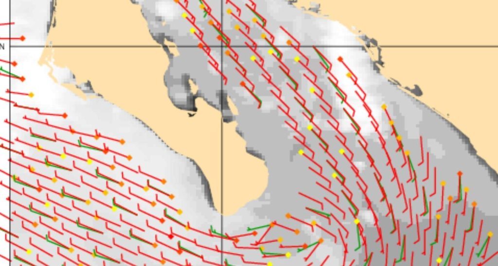
¡Buenos dias! An Oceansat satellite pass around midnight measured WNW winds of around 10 knots east of Cerralvo, and several of the latest numerical model forecasts show sufficient NW to N background flow will continue into the early afternoon today. That said, a couple of the more reliable models are now showing north winds peaking during the early afternoon, then the dreaded east flow pushing into the southern beaches by mid afternoon. Mid to high-level clouds early this morning will push off to the east by midday, but more mid-level clouds may sneak in by mid afternoon, and that could tend to dampen our thermal as well. The rest of the forecast looks to be on track, as steady north flow is forecast to continue on Thursday, then increase a bit on Friday into Saturday. There will be some high clouds from time to time through Friday, but enough filtered sun should sneak through to help jump start our local thermal. Full sunshine will likely return on Saturday and Sunday, and our local thermal will likely be in fine form. The background north flow is forecast to weaken on Monday, but just enough may remain to bring us one more rideable day. Long-range model forecasts are in good agreement that Tuesday will see only light onshore flow.

  • Today…Becoming sunny by late morning, then increasing clouds during the afternoon. North wind 16-18 mph…becoming east at 8-10 mph on southern beaches around mid afternoon.
  • Thursday…Mostly sunny. Northeast wind 16-18 mph.
  • Friday…Mostly sunny. North wind 16-20 mph.
  • Saturday…Sunny. North wind 18-22 mph.
  • Sunday…Sunny. North wind 18-22 mph.
  • Monday…Mostly sunny. North wind 16-18 mph.
  • Tuesday…Mostly sunny. East wind 8-10 mph.

Wind – April 15, 2025

¡Buenos dias! An Oceansat satellite pass around midnight measured 5-10 knot northwest winds over the Sea of Cortez just east of Cerralvo, and most of the model forecasts show solid north background flow for today. Infrared satellite loops depicted a large area of high, relatively thin clouds streaming in from the southwest, but there should be sufficient filtered sun today to give us at least a partial thermal boost. I will mention that the HRRR model is forecasting a BIG thermal boost even with all of the high clouds, so I wouldn’t be surprised if winds are stronger than I have forecast for today. The remainder of the forecast remains intact as models are in reasonable good agreement that we will see sufficient north background flow through Friday. Some thin, high clouds will continue to stream in from time to time, but they shouldn’t be thermal killers. The surface pressure gradient is forecast to tighten some on Saturday in Sunday, so Semana Santa revelers should be prepared for windy afternoons. We may see just enough north flow linger into Monday to give us one more rideable day.

  • Today…Partly sunny. North wind 16-20 mph.
  • Wednesday…Sunny. North wind 18-22 mph.
  • Thursday…Mostly sunny. Northeast wind 16-18 mph.
  • Friday…Mostly sunny. North wind 16-18 mph.
  • Saturday…Sunny. North wind 18-22 mph.
  • Sunday…Sunny. North wind 18-22 mph.
  • Monday…Mostly sunny. North wind 16-18 mph.

Wind – April 14, 2025

¡Buenos dias! A satellite pass last evening measured light southeast winds over the southern Sea of Cortez, and all of the most recent numerical model forecasts show ligtht background flow will continue today. Infrared satellite images early this morning showed some high clouds moving in from the west, and another area of fog and low clouds approaching from the east (see nerd note below). Model forecasts continue to be in good agreement that we will see a tightening of the surface pressure gradient over BCS on Tuesday, with north background flow returning. The big wild card for Tuesday continues to be the thickness of high cloud cover, but at least one of the models shows indications of some thin spots in the cloud shield, so we should see enough filtered sun to help partially activate our local thermal. Model forecasts now show sunny skies will likely return on Wednesday and with ample north background flow, we should see a windy afternoon. Several of the models show the surface pressure gradient weakening a bit on Thursday, but with another sunny day expected we may see a marginally rideable day. The background north flow is then forecast to increase again on Friday into Saturday, with solid north flow lasting through the Semana Santa weekend.

  • Today…Mostly sunny. East wind 8-10 mph.
  • Tuesday…Partly sunny. North wind 16-18 mph.
  • Wednesday…Sunny. North wind 16-20 mph.
  • Thursday…Sunny. Northeast wind 14-16 mph.
  • Friday…Mostly sunny. North wind 16-18 mph.
  • Saturday…Mostly sunny. North wind 18-22 mph.
  • Sunday…Mostly sunny. North wind 18-22 mph.

Nerd Note: The dramatic low clouds and fog that we’ve seen the last couple of mornings is a sea fog which is formed as warm and moist air flows over relatively cool ocean water. The sea suface temperature near La Ventana is still relatively cool, at around 71 F, but to the southeast the sea surface temperatures are already in the mid 70s (see NOAA graphic below). The light southeast winds that we’ve seen over the past couple of days (shown in the Haiyang satellite image) have brought relatively warm and moist air from the southeast over the still relatively cool waters farther north near us. As this happens, the low levels are chilled to near the dewpoint (low 70s), the air becomes saturated, and fog forms. A NOAA satellite loop this morning showed another band of low clouds and fog moving our way early this morning, so we may see a repeat of the mid-morning fog.

Wind – April 13, 2025

¡Buenos dias! A couple of satellite passes around midnight measured light south to southeast winds over the southern Sea of Cortez, and all model forecasts for today point to another light wind day. A couple of the latest model runs show a weak north pulse developing on Monday afternoon, with the best chance for kiteable winds on the northern beaches…we’ll see if that trend holds over the next few model runs. On Tuesday models are in good agreement that the surface pressure gradient will tighten over BCS, with north background flow returning. The one potential fly in the ointment for Tuesday will be the thickness of high cloud cover, as all of the models show increasing high clouds which will at least partially dampen our local thermal. At this point I’ll be optimistic, as it still appears that there may be enough filtered strong April sunshine to help trigger our wind machine on Tuesday. Model forecasts continue to be in good agreement that we will see sufficient north background flow continue from Wednesday through much of the upcoming week, with a possible pause on Thursday. High clouds will continue to stream in from time to time through the upcoming Semana Santa week, but models show patches of clearing as well so we should see enough sun to help jump start our local thermal each day.

  • Today…Mostly sunny. East wind 8-10 mph.
  • Monday…Mostly sunny. Northeast to north wind 10-12 mph…possibly higher on northern beaches.
  • Tuesday…Partly sunny. North wind 16-18 mph.
  • Wednesday…Mostly sunny. North wind 16-18 mph.
  • Thursday…Mostly sunny. Northeast wind 12-14 mph.
  • Friday…Mostly sunny. North wind 16-18 mph.
  • Saturday…Mostly sunny. North wind 16-20 mph.

Wind – April 12, 2025

¡Buenos dias! A satellite pass last evening measured light and variable winds just east of Cerralvo, and all of the latest numerical model forecasts show only a light onshore breeze for this afternoon. Similar conditions are expected through Monday, then the models are in good agreement that the surface pressure gradient will tighten a bit over BCS on Tuesday, with north background flow increasing. The wild card for Tuesday will be the thickness of high cloud cover, but for now I’ll be optimistic and forecast enough thin spots in the cloud cover to bring us at least a partial thermal boost. Clouds should thin on Wednesday and with sufficient north background flow forecast to continue, we should see a rideable day. Models show the north flow decreasing a bit on Thursday, but increasing again on Friday. Long-range forecasts are in good agreement that solid north background flow will then continue through the Semana Santa weekend.

  • Today…Sunny. East wind 8-10 mph.
  • Sunday…Mostly sunny. East wind 8-10 mph.
  • Monday…Mostly sunny. Northeast wind 10-12 mph.
  • Tuesday…Partly sunny. North wind 16-18 mph.
  • Wednesday…Mostly sunny. North wind 16-18 mph.
  • Thursday…Mostly sunny. Northeast wind 10-12 mph.
  • Friday…Mostly sunny. North wind 16-18 mph.

Wind – April 11, 2025

¡Buenos dias! Northern beaches got a bonus day yesterday, as Rasta beach saw a pulse of north wind at 14-16 mph from around 3 pm until just after 6 pm. As one of you astutely pointed out, some of the HRRR model hourly runs yesterday did show that possibility, but the model was inconsistent run to run. The latest HRRR run for today shows an even weaker north pulse just reaching Aguas Calientes by around 3-4 pm, but confidence is very low that we’ll see a repeat of yesterday. Otherwise the latest model forecasts continue to be in excellent agreement that we will see light winds lasting through Monday, then the surface pressure gradient is forecast to tighten over BCS on Tuesday and produce enough north flow to again jump start our local wind machine. At this point the long-range models are in good agreement that sufficient north flow for rideable days will then last into the upcoming Semana Santa weekend. We will likely see some high clouds during that time, but we should see enough thin spots to allow for local thermal boosts each day from Tuesday through next weekend.

  • Today…Sunny. East wind 8-10 mph.
  • Saturday…Sunny. East wind 8-10 mph.
  • Sunday…Sunny. East wind 8-10 mph.
  • Monday…Mostly sunny. East wind 8-10 mph.
  • Tuesday…Mostly sunny. North wind 16-20 mph.
  • Wednesday…Mostly sunny. North wind 16-20 mph.
  • Thursday…Mostly sunny. North wind 16-18 mph.

Wind – April 10, 2025

¡Buenos dias! An Oceansat satellite pass last evening measured light and variable winds over the Sea of Cortez just east of Cerralvo. Model forecasts remain in excellent agreement that a light wind regime will continue over BCS through Monday, with only light onshore breezes expected each afternoon. Long-range models are in good agreement that the surface pressure gradient will tighten a bit on Tuesday into Wednesday, with some north background flow returning.

  • Today…Sunny. Northeast wind 10-12 mph.
  • Friday…Sunny. East wind 8-10 mph.
  • Saturday…Sunny. East wind 8-10 mph.
  • Sunday…Sunny. East wind 8-10 mph.
  • Monday…Mostly sunny. East wind 8-10 mph.
  • Tuesday…Mostly sunny. North wind 16-18 mph.
  • Wednesday…Mostly sunny. North wind 16-18 mph.

Wind – April 9, 2025

¡Buenos dias! An ASCAT satellite pass last evening measured W to NW winds of around 5 knots over the Sea of Cortez just east of Cerralvo. All of the most recent numerical model runs show a light wind regime over BCS today and lasting through Monday. There is some hope to see a pulse of north flow next Tuesday.

  • Today…Sunny. East wind 8-10 mph.
  • Thursday…Sunny. Northeast wind 10-12 mph.
  • Friday…Sunny. East wind 8-10 mph.
  • Saturday…Sunny. East wind 8-10 mph.
  • Sunday…Sunny. East wind 8-10 mph.
  • Monday…Mostly sunny. East wind 8-10 mph.
  • Tuesday…Mostly sunny. North wind 16-18 mph.

Wind – April 8, 2025

¡Buenos dias! An Oceansat satellite pass just after midnight confirmed that the norte has died, as it measured NNW winds of around 10 knots over the Sea of Cortez just east of Cerralvo. The vast majority of model forecasts show we will see sufficient background north flow remaining today to help jump-start our local wind machine. Infrared satellite loops early this morning showed another sunny day ahead, so we will also see a good thermal boost. Models continue to show a light wind regime setting in on Wednesday and lasting into next week. Extended-range model forecasts do show hope for a return of some north flow during the middle of next week.

  • Today…Sunny. North wind 16-20 mph.
  • Wednesday…Sunny. East wind 8-10 mph.
  • Thursday…Sunny. Northeast wind 10-12 mph.
  • Friday…Sunny. East wind 8-10 mph.
  • Saturday…Sunny. East wind 8-10 mph.
  • Sunday…Sunny. East wind 8-10 mph.
  • Monday…Sunny. Northeast wind 10-12 mph.

Wind – April 7, 2025

¡Buenos dias! The mountain wave that the HRRR model forecast yesterday did indeed materialize overnight. The highest gust I have seen was 53 mph at Club Cerralvo at 4:39 am, with more sheltered locations right along the beach gusting in the mid 30s. The local mountain wave gusts will diminish this morning and the more widespread norte will also ease up a bit this afternoon. That said, we’ll still see strong to moderate NNW background flow continuing this afternoon, and our local thermal should pull much of the west out of the background flow, especially on southern beaches. Northern beaches will likely continue to see some wind-shadowing and gusty conditions this afternoon. Models are in good agreement that we will see a more typical La Ventana pure thermal day on Tuesday, with good quality side-onshore winds. A light wind regime will then take hold on Wednesday and last through at least Sunday with only light onshore breezes each afternoon.

  • Today…Sunny. Northwest winds gusting to 40 mph early this morning, then becoming north…northwest to north at 20-24 mph.
  • Tuesday…Sunny. North wind 16-20 mph.
  • Wednesday…Sunny. East wind 8-10 mph.
  • Thursday…Sunny. East wind 8-10 mph.
  • Friday…Sunny. East wind 8-10 mph.
  • Saturday…Sunny. East wind 8-10 mph.
  • Sunday…Sunny. East wind 8-10 mph