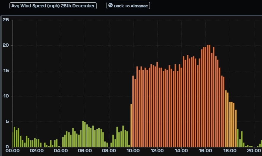
¡Buenos dias! The wind gauge at the campground yesterday showed an unusual stairstep pattern, with sustained winds of 14-16 mph from around 10 am until 2 pm, then a bump to 16-18 mph from 2 until 3:30, then a final bump to 19-20 mph from 3:40 until 4:40 (see image below). Several of the latest model forecasts show the background flow peaking at 3-4 pm this afternoon, so we may see another day of rigging changes. Models show a similar pattern of a mid-late afternoon peak in winds on Saturday, with slightly stronger winds possible. The surface high anchored far to our north should remain in place on Sunday, giving us one more rideable day. All of the forecast models indicate that we’ll get a rest day on Monday, as the surface pressure gradient over BCS becomes very weak. Surface high pressure will begin building back into the interior west of the U.S. on Tuesday, and we should see north background flow increase just enough to help jump start our local wind machine. As the surface high continues to build to the southeast on Wednesday, models show our background north flow increasing substantially, with moderate to strong flow continuing into Thursday.
- Today…Mostly sunny. North wind increasing to 16-20 mph by mid afternoon.
- Saturday…Sunny. North wind 18-22 mph.
- Sunday…Sunny. North wind 16-20 mph.
- Monday…Sunny. North wind 10-12 mph.
- Tuesday…Sunny. North wind 16-18 mph.
- Wednesday…Sunny. North wind 18-22 mph.
- Thursday…Sunny. North wind 18-22 mph.
