¡Buenos dias! Satellite passes late last evening measured 15 knot winds over the Sea of Cortez just east of Cerralvo, and all of the most recent numerical model forecasts show moderate to strong north…northwest background flow will continue today. Infrared satellite loops early this morning indicated another sunny day ahead for our region, setting the stage for a big thermal boost. This latest windy streak will continue on Sunday, as model forecasts show surface high pressure building into the 4-corners region of the U.S., thereby keeping a tight surface pressure gradient in place over BCS. A progressive weather pattern will continue, as another storm system moves into California on Monday and nudges the surface high to our north southward, with light background flow returning here. As the storm system continues eastward on Tuesday, surface high pressure will again build into the interior west of the U.S. and send a new pulse of north flow down the Sea of Cortez. Long-range model forecasts are in excellent agreement that norte conditions will arrive on Wednesday, with typical gusty conditions. The norte will subside on Thursday, but solid north background flow will likely continue and with sunny skies expected we should see another windy afternoon. Yet another storm system will begin to affect the western U.S. on Friday and our winds will likely become light.
- Today…Sunny. North wind 20-24 mph.
- Sunday…Mostly sunny. North wind 20-24 mph.
- Monday…Sunny. Northeast wind 10-12 mph.
- Tuesday…Sunny. North wind 16-20 mph.
- Wednesday…Mostly sunny. North wind 22-26 mph and gusty.
- Thursday…Sunny. North wind 18-22 mph.
- Friday…Mostly sunny. East wind 10-12 mph.
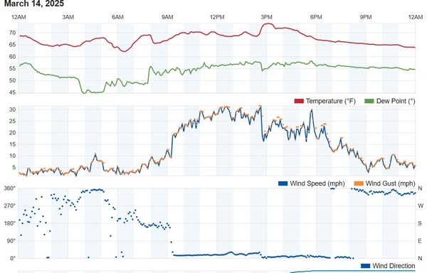
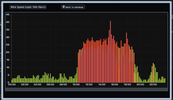
Nerd Note: For much of the afternoon yesterday, area wind graphs at Rasta Beach and the campground (see below) showed relatively steady winds of around 20-24 mph (note that the Rasta Beach gauge plots 1-minute sustained winds as opposed to the 10-minute average at the campground, so winds are typically 4-5 mph higher there). Then around 2:30 things started to get really weird. The solid NE flow at Rasta rapidly shifted to due north, and wind speeds dropped like a rock (personal observation). At the campground, winds increased dramatically at around 3 pm, then peaked with a wind gust of 41 mph at 3:20 pm… the highest wind gust of the season. A surge in the west component of the winds at Rasta was likely the cause of the dramatic change there, but I don’t have a good explanation of why the campground recorded such a high wind gust.