¡Buenos dias! Infrared satellite loops early this morning showed patches of low clouds racing from north to south near Cerralvo, and this is likely the leading edge of a new surge of north background flow. Model forecasts are in excellent agreement that surface high pressure centered over the eastern Pacific will move eastward today and another surface high centered over Nevada will build southeastward towards the 4-corners region of the U.S. This squeeze play will create a very tight surface pressure gradient over BCS, with norte conditions developing by this afternoon. The norte is forecast to peak during the early morning hours of Sunday, with norte conditions likely lasting through Sunday afternoon. Monday will be a very different day, as a surface low pressure system approaches southern California causing the background flow here to fall to just below the threshold for fully activating our local wind machine. As the surface low moves inland over far southern California and northern Baja California on Tuesday (see nerd note below), the background flow over BCS will remain weak with only light onshore breezes expected during the afternoon. Models are in good agreement that an east-west oriented ridge of high pressure will then set up just to our north on Wednesday and bring us a return of north background wind. Long-range model forecasts show and active weather pattern continuing to our north, as another storm system impacts California and northern Baja California on Thursday and causes our winds to once again become light. Models show the storm system will then continue eastward on Friday and allow surface high pressure to build back into the Baja Peninsula, with north flow returning.
- Today…A few morning low clouds, then sunny. North wind 22-26 mph and gusty.
- Sunday…Sunny. North wind 22-26 mph.
- Monday…Sunny. North wind 14-16 mph.
- Tuesday…Sunny. East wind 8-10 mph.
- Wednesday…Sunny. North wind 16-20 mph.
- Thursday…Mostly sunny. Northwest wind 10-12 mph.
- Friday…Mostly sunny. North wind 18-22 mph.
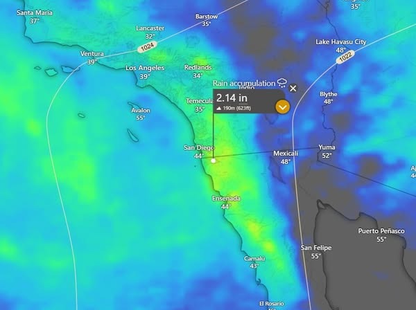
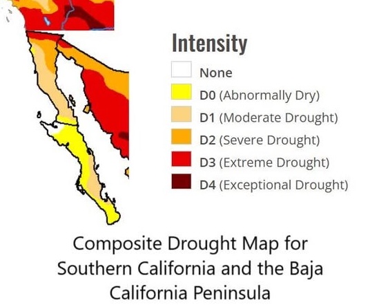
Nerd Note: The next 7 days have the potential to bring some much-needed rain to areas of southern California and the northern Baja Peninsula where severe to extreme drought conditions exist. The first image below shows the forecast accumulated rainfall for the next 7 days, with some areas forecast to receive nearly 2 inches. The second image is a rough composite map showing the most recent drought assessment. Note that much of far southern California and far northern Baja California are in the extreme drought category.